Picture |
Object
name
#NORAD |
Description |
Launch
Date |
Weight |

|
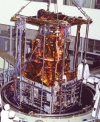
EROS
B-1
EROS B1
#29079
(2006-014A) |
EROS B-1 (Earth
Resources Observation Satellite) is an Israeli commercial/military
photo-imaging satellite that was launched by a START
1 rocket(SS-25) from a mobile pad at Svobodny in far-eastern
Russia . The satellite is capable of taking images at
a resolution of 70 cm. |
Apr
25th 2006 |
360 kg |
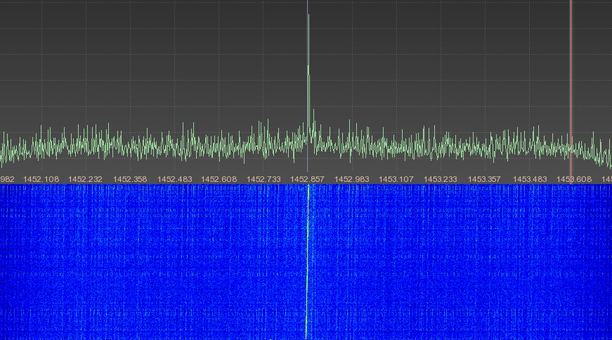
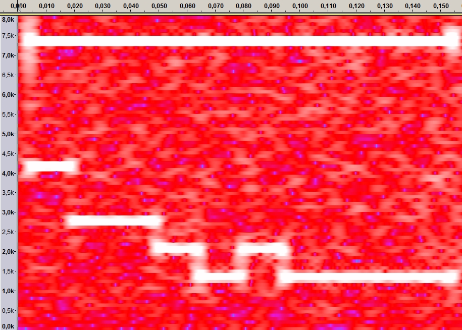
 The
S-Band downlink on 2295 MHz of EROS B-1 was received
and enclosed FFT plot was generated in April 2014 by
Milen Rangelov. The
S-Band downlink on 2295 MHz of EROS B-1 was received
and enclosed FFT plot was generated in April 2014 by
Milen Rangelov.
|


|
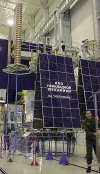
EWS-G1
GOES-13
GOES-N
#29155
(2006-018A) |
GOES
13 is an American (NOAA) geostationary weather satellite
that was launched by a Delta IV rocket from Cape Canaveral
on 24 May 24th 2006 at 22:11
UTC. It carries the usual set of GOES monitors: imager,
sounder, SEM package, X-ray imager, energetic particle
detector, and ground-data relaying equipment. It was
placed in orbit originally as a spare.
On April 14th
2010 GOES-13 became the operational weather satellite
for GOES-East. On November 20th
2015 at 09:22 UTC, GOES-13 experienced an anomaly. It
was determined that the Filter Wheel had stopped moving
(the filter wheel aligns the infrared detectors with
the incoming data) so data were not scanned. All 18
infrared channels were affected. Only the visible channel
(band 19) continued sending usable data.
GOES-13 was replaced
by GOES-16 on December 18th
2017 and it was parked at 60 degree West as a backup
satellite.
In 2020 it was
moved to 61.5 degree East and since September 8th
2020 is covering the Indian Ocean as EWS-G1. It has
a projected emd of service date of January 2024, possibly
longer.
From Southern Germany
EWS-G1 is visible with an azimuth of 118.7 degree and
an elevation of 14.9 degree.
It is transmitting
in L-band using the following frequencies:
- 1685.7 MHz GVAR (GOES VARiable transmission format
in BPSK) using linear polarization.
- 1676 MHz SD (Sensor Data)
Enclosed picture
was received on April 5th 2021
at 07:41 UTC on 1685.7 MHz by DD1US. The picture is
noisy as I have a mountain right in that direction and
I was using a circular polarized feed.  Should
be able to get a noise free signal when building and
using a linear polarized feed. Decoded with SatDump
from @Aang254.
Size of the original picture was about 2000x2000pixels. Should
be able to get a noise free signal when building and
using a linear polarized feed. Decoded with SatDump
from @Aang254.
Size of the original picture was about 2000x2000pixels. |
May 24th
2006 |
2340 kg |


|
HINODE
SOLAR B
#29479
(2006-041A) |
The Solar-B mission
consists of a coordinated set of optical, X-ray and
EUV telescopes. The optical telescope is a diffraction
limited, aplanatic Gregorian with an aperture of 0.5
m. It provides angular resolution of about 0.2 arcsec
over the field of view of about 400 × 400 arcsec.
The focal plane package of the optical telescope consists
of a filter vector magnetograph and a spectro-polarimeter.
This combination allows us to obtain, for the first
time, a continuous series of high-precision vector magnetograms,
Dopplergrams, and filtergrams with sub-arcsec resolution.
The X-ray telescope images the high temperature (0.5
to 10 MK) corona with improved angular resolution, say
approximately 1 arcsec, a few times better than Yohkoh's
soft X-ray telescope. The Extreme Ultraviolet (EUV)
Imaging Spectrometer aims to determine velocity fields
and other plasma parameters in the corona and transition
region, thus helping to relate coronal dynamic behavior,
observed with the X-ray telescope, to the underlying
photospheric magnetic field, observed with the optical
telescope. The EUV-imaging spectrometer is also expected
to unveil inflow and outflow of magnetic reconnection,
and hence together with the two other telescopes, to
finally solve long-standing controversies on coronal
heating and dynamics. After the successful launch, Solar
B has been renamed to Hinode ("Sunrise"). |
Sep
22nd 2006 |
870 kg |
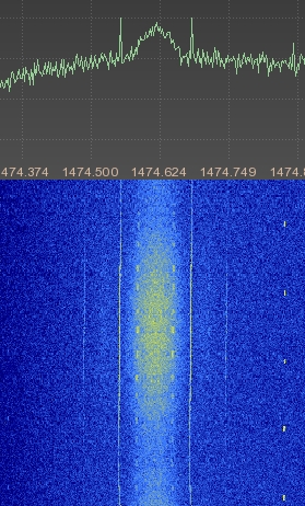
 The
S-Band TT&C downlink on 2256.22 MHz of HINODE was
received and enclosed FFT plot was generated in June
2014 by Milen Rangelov. The
S-Band TT&C downlink on 2256.22 MHz of HINODE was
received and enclosed FFT plot was generated in June
2014 by Milen Rangelov.
|


|
MetOp-A
#29499
(2006-044A) |
MetOp-A is the first
European polar orbiting satellite. MetOp-A carries a
suite of 13 instruments to closely observe weather systems
and climate trends. Five of these are considered new
and were developed in Europe. The others are provided
by NOAA and the French space agency, CNES, having flown
on several earlier U.S. weather satellites. MetOp-A
includes an UHF receiver (401.65 MHz) and signal processor
for locating and/or collecting meteorological data from
remote fixed and free floating terrestrial and atmospheric
platforms. The UHF downlink for this ADCS (Advanced
Data Collection System) system is at 465.9875 MHz where
Metop-A transmits data with 200 bit/s or 400 bit/s.
Furthermore it features a VHF/UHF transponder and signal
processor for locating and collecting information from
remote distress platforms such as Emergency Locator
Transmitters (ELTs) transmitting on 121.5 (±
20 kHz), 243.0 (± 30 kHz), and 406.05 MHz (±
80 kHz), and Emergency Position Indicating Radio Beacons
(EPIRBs) transmitting on 406 MHz. These bands are then
summed with 2.4 kbps data from the SARP-3 (beacons of
aircraft and ships in distress) unit and the resulting
signal phase-modulates the L-band downlink transmitter
(1544.5 MHz ± 400 kHz).
|
Oct
19th 2006 |
4100
kg |
  The
spectrum plots of the S-Band downlink at 2230 MHz were
recorded by Paul M0YET on Sept 30th
2007 at 20:43UTC and on Nov 13th 2007 at 10:42UTC. The
spectrum plots of the S-Band downlink at 2230 MHz were
recorded by Paul M0YET on Sept 30th
2007 at 20:43UTC and on Nov 13th 2007 at 10:42UTC.
|
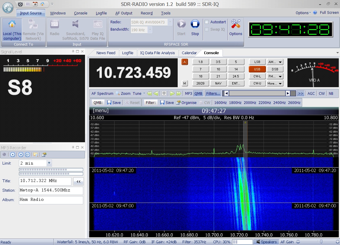
  Enclosed
audio signal of the L-band downlink of Metop-A was received
on May 2nd 2011 at 09:47 UTC
at 1544.500 MHz in USB. Many thanks to Greg Roberts
for kindly providing this recording. Enclosed
audio signal of the L-band downlink of Metop-A was received
on May 2nd 2011 at 09:47 UTC
at 1544.500 MHz in USB. Many thanks to Greg Roberts
for kindly providing this recording.
|
Enclosed
audio signal from Metop-A was received on December 28nd
2011 at 21:08 UTC at 2230 MHz. Many thanks to Paul Marsh
for kindly providing this recording. |

|
GeneSat-1
#29655
(2006-058C) |
GeneSat-1
was built by NASA and Santa Clara State University and
carried biological experiments (E.Coli K-12 bacteria).
It used the ham radio callsign KE7EGC in spite of the
fact that it was not an official ham radio satellite.
It operated on a downlink of 437.067 MHz and transmitted
1200bd AX.25 packets. Recorded on December 17th
2006 at 03:22 UTC on 437.067 MHz in FM by Mike DK3WN. |
Dec 16th
2006 |
4.6 kg |

|
IRS-P7
Cartosat 2
Cartosat
2AT
#29710
(2007-001B) |
CartoSat
2 is an Indian photo-imaging craft that was launched
by a PSLV-C7 rocket from Sriharikota. The spacecraft
provides panchromatic images at one-meter resolution,
to aid civil planning, and other cartographic needs.
Cartosat-2
suffered from some problems after launch. |
Jan
10th 2007 |
680
kg |
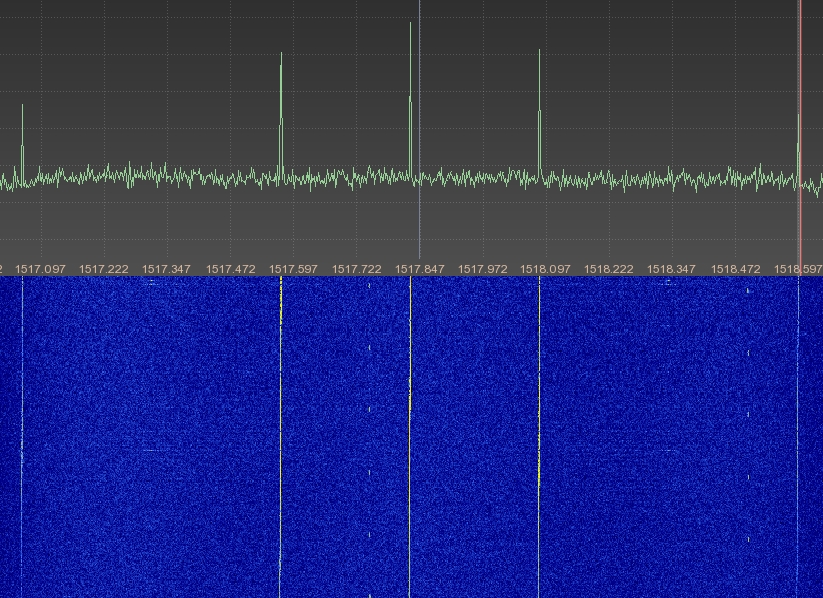
 The
S-Band downlink on 2245.7 MHz of IRS-P7 was received
and enclosed FFT plot was generated between March and
May 2014 by Milen Rangelov. The
S-Band downlink on 2245.7 MHz of IRS-P7 was received
and enclosed FFT plot was generated between March and
May 2014 by Milen Rangelov.
|

|
Saudisat-3
#31118
(2007-012B) |
SaudiSat 3 is a Saudi
Arabian minisatellite that was launched by a Dnepr rocket
from Baikonur. The minisatellite carries a high resolution
imager, built in collaboration with KACST's faculty
and students. |
Apr
17th 2007 |
200
kg |
 Enclosed
audio files as well as the waterfall diagrams were recorded
on October 7th 2012 around
20:30 UTC on 422.123 MHz while Saudisat-3 was in range
of Arabia and thus transmitting. Please note that Saudisat-3
is not always transmittin gin that format. Kindly provided
by Darko 9A3LI. Enclosed
audio files as well as the waterfall diagrams were recorded
on October 7th 2012 around
20:30 UTC on 422.123 MHz while Saudisat-3 was in range
of Arabia and thus transmitting. Please note that Saudisat-3
is not always transmittin gin that format. Kindly provided
by Darko 9A3LI.
|
 Enclosed
audio files as well as the waterfall diagrams were recorded
on October 7th 2012 around
22:43 UTC on 422.490 MHz while Saudisat-3 was in range
of Arabia and thus transmitting. Please note that Saudisat-3
is not always transmittin gin that format. Kindly provided
by Darko 9A3LI. Enclosed
audio files as well as the waterfall diagrams were recorded
on October 7th 2012 around
22:43 UTC on 422.490 MHz while Saudisat-3 was in range
of Arabia and thus transmitting. Please note that Saudisat-3
is not always transmittin gin that format. Kindly provided
by Darko 9A3LI.
|


|
AIM
Explorer 90
#31304
(2007-015A) |
The scientific purpose
of the Aeronomy of Ice in the Mesosphere (AIM) mission
is focused on the study of Polar Mesospheric Clouds
(PMCs) that form about 50 miles above the Earth's surface
in summer and mostly in the polar regions. The overall
goal is to resolve why PMCs form and why they vary.
AIM e
was launched into a circular 550 km sun-synchronous
noon orbit by a Pegasus rocket Its expected
lifetime was at least two years. |
Apr
25th 2007 |
200
kg |
 The
S-Band downlink on 2283.5 MHz of AIM was received and
enclosed FFT plot was generated in March 2014 by Milen
Rangelov. The
S-Band downlink on 2283.5 MHz of AIM was received and
enclosed FFT plot was generated in March 2014 by Milen
Rangelov.
|

|
COSMO-Skymed
1
SKYMED 1
#31598
(2007-023A) |
COSMO-SkyMed 1 is
an Italian Earth-imaging Synthetic Aperture Radar that
was launched by a Delta 2 rocket from Vandenberg AFB.
COSMO is the abbreviation of COnstellation of
small Satellites for the Mediterranean basin Observation.
It
is a dual use satellite (civilian and military use).
The 1.7 ton, 3.6 kW craft is the first of a four-satellite
constellation, and carries an X-band (9.6 GHz) radar.
The swath width is variable and provides images at a
resolution between 1 to 100 meters (in civilian mode). |
Jun
8th 2007 |
1700
kg |
 The
S-Band downlink on 2230 MHz of SKYMED 1 was received
and enclosed FFT plot was generated in April 2014 by
Milen Rangelov. The
S-Band downlink on 2230 MHz of SKYMED 1 was received
and enclosed FFT plot was generated in April 2014 by
Milen Rangelov.
|

|
Sar-Lupe
3
#32283
(2007-053A) |
Sar
Lupe 3 is a German military, Synthetic Aperture Radar
(SAR) satellite that was launched by a Kosmos 3M rocket
from Plesetsk into a 486 km high LEO. The radar operates
at an X-band frequency to provide images at less than
one-meter resolution. The
Sar-Lupe system is a constellation of five identical
satellites in three orbital planes. |
Nov
1st 2007 |
770
kg |
 The
S-Band downlink on 2273 MHz of Sar-Lupe 3 was received
and enclosed FFT plot was generated in April to May
2014 by Milen Rangelov. The
S-Band downlink on 2273 MHz of Sar-Lupe 3 was received
and enclosed FFT plot was generated in April to May
2014 by Milen Rangelov.
|

|
COSMO-Skymed
2
SKYMED 2
#32376
(2007-059A) |
COSMO-SkyMed 2 is
an Italian Earth-imaging Synthetic Aperture Radar that
was launched by a Delta 2 rocket from Vandenberg AFB.
COSMO is the abbreviation of COnstellation of
small Satellites for the Mediterranean basin Observation.
It
is a dual use satellite (civilian and military use).
The 1.7 ton, 3.6 kW craft is the second of a four-satellite
constellation, and carries an X-band (9.6 GHz) radar.
The swath width is variable and provides images at a
resolution between 1 to 100 meters (in civilian mode).
|
Dec
9th 2007 |
1700
kg |
 The
S-Band downlink on 2230 MHz of SKYMED 2 was received
and enclosed FFT plot was generated in April 2014 by
Milen Rangelov. The
S-Band downlink on 2230 MHz of SKYMED 2 was received
and enclosed FFT plot was generated in April 2014 by
Milen Rangelov.
|


|
IRS-2A
Cartosat-2A
#32783
(2008-021A) |
Cartosat-2A is an
advanced remote sensing satellite with a single panchromatic
camera capable of providing scene-specific spot imageries
for cartographic applications. The camera is designed
to provide imageries with better than one meter spatial
resolution and a swath of 10 km. The satellite has high
agility with capability to steer along and across the
track up to + 45 degrees. It was placed in a sun-synchronous
polar orbit at an altitude of 630 km. |
Apr
28h 2008 |
690
kg |
 The
S-Band downlink on 2245.7 MHz of IRS-2A was received
and enclosed FFT plot was generated between March and
May 2014 by Milen Rangelov. The
S-Band downlink on 2245.7 MHz of IRS-2A was received
and enclosed FFT plot was generated between March and
May 2014 by Milen Rangelov.
|

|
CanX-2
#32797
(2008-021L) |
CanX-2 (Canadian
Advanced Nanospace eXperiments) was built by University
of Toronto, Canada and was launched together with 6
amateur radio cubesats. With a size of 10x10x34cm and
a weight of 3.5 kg it is the second nano-satellite within
the Canadian Advanced Nanospace eXpermiment (CanX).
CanX-2 transmits data on its S-band downlink in the
2.2 GHz Space Research Service Band. Due to power limitations
this transmitter is only activated when the satellite
is over the ground station in Toronto, Canada. Its 70cm
transmitter (437.478 MHz, 4 kbps GFSK) has not been
turned on yet. |
Apr 28th
2008 |
3.5 kg |

|
COSMOS
2438
KOSMOS 2438
Strela-3 #138
#32955
(2008-025C) |
Cosmos 2438 was launched
together with Cosmos 2437 and COMOS 2439 by a Rokot-KM
rocket from Plesetsk on May 23rd
2008. COSMOS 2438 is used for store-dump communications
by Russian government and military. |
May
23rd 2008 |
200
kg |
COSMOS
2438 was received by Roland Proesch DF3LZ on December
26th 2013 at 15:21 UTC on 244.5125
MHz in USB.
 The
first sound file contains multiple bursts, the second
soundfile only a single burst. The
first sound file contains multiple bursts, the second
soundfile only a single burst.  The
spectrogam shows the ID of the satellite. Sound files
kindly provided by Roland Proesch DF3LZ. The
spectrogam shows the ID of the satellite. Sound files
kindly provided by Roland Proesch DF3LZ. |
|
Sar-Lupe
5
#33244
(2008-036A) |
Sar
Lupe 5 is a German military, Synthetic Aperture Radar
(SAR) satellite that was launched by a Kosmos 3M rocket
from Plesetsk into a 484km high LEO. The radar operates
at an X-band frequency to provide images at less than
one-meter resolution. The
Sar-Lupe system is a constellation of five identical
satellites in three orbital planes. |
July
22nd 2008 |
770
kg |
 The
S-Band downlink on 2273 MHz of Sar-Lupe 5 was received
and enclosed FFT plot was generated in April to May
2014 by Milen Rangelov. The
S-Band downlink on 2273 MHz of Sar-Lupe 5 was received
and enclosed FFT plot was generated in April to May
2014 by Milen Rangelov.
|

|
COSMO-Skymed
3
SKYMED 3
#33412
(2008-054A) |
COSMO-SkyMed 3 is
an Italian Earth-imaging Synthetic Aperture Radar that
was launched by a Delta 2 rocket from Vandenberg AFB.
COSMO is the abbreviation of COnstellation of
small Satellites for the Mediterranean basin Observation.
It
is a dual use satellite (civilian and military use).
The 1.7 ton, 3.6 kW craft is the second of a four-satellite
constellation, and carries an X-band (9.6 GHz) radar.
The swath width is variable and provides images at a
resolution between 1 to 100 meters (in civilian mode).
|
Oct
25th 2008 |
1700
kg |
 The
S-Band downlink on 2230 MHz of SKYMED 3 was received
and enclosed FFT plot was generated in May 2014 by Milen
Rangelov. The
S-Band downlink on 2230 MHz of SKYMED 3 was received
and enclosed FFT plot was generated in May 2014 by Milen
Rangelov.
|

|
STS-126
Endeavour OV-105
#33441
(2008-059A) |
STS-126
is the 27th shuttle mission to the International Space
Station. STS-126 delivered the italian MPLM (multi purpose
logistic module) "Leonardo" which gave the
International Space Station ISS the ability to support
twice the crew than previously living there.
 The
spectrum plot of the S-band downlink at 2217.5 MHz was
recorded on November 16th 2008 05:17UTC by Loren WA7SKT.
You can see the multiple subcarriers containing data. The
spectrum plot of the S-band downlink at 2217.5 MHz was
recorded on November 16th 2008 05:17UTC by Loren WA7SKT.
You can see the multiple subcarriers containing data. |
Nov 15th
2008 |
2048979
kg |

|
Yaogan-4
YG 4
JB-6 2
#33446
(2008-061A) |
Yaogan 4 is a remote
sensing satellite launched on a Long March 2D rocket
from Jiuquan Satellite Launch Center in northwestern
China's Gansu Province into a 652km high LEO. |
Dec
1st 2008 |
xx
kg |
 The
S-Band downlink on 2216.55 MHz of Yaogan-4 was received
and enclosed FFT plot was generated between March and
May 2014 by Milen Rangelov. The
S-Band downlink on 2216.55 MHz of Yaogan-4 was received
and enclosed FFT plot was generated between March and
May 2014 by Milen Rangelov.
|


|
OMID
#33506
(2009-004A) |
OMID (Iranian
for "hope") is the 1st
satellite built and launched domestically by Iran on
a Safir 2 rocket. It is a small technology satellite
carrying an instrument to measure the space environment,
and a GPS receiver modified for use in the unstabilized
satellite. Its mission is defined to be data-processing
for research and telecommunications. The downlink frequencies
coordinated by ITU are 464.98750 MHz and 465.01250
MHz (@ +7 dBW). The uplink command frequency is at 401
MHz. |
Feb
2nd 2009 |
25
kg |
The telemetry
downlink signal was received by Paul M0YET using a receiver
with a NFM demodulator (15kHz bandwidth). It is a 600Bd
manchester encoded data stream (300Bd data). |
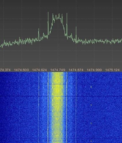
 Paul
M0YET kindly provided the enclosed spectrum plot of
the downlink signal which he recorded on Feb 4th
2009 at 17:18h UTC. Please note that the downlink is
not continuously activated and seems to be switched
between 2 different TX modes. Paul
M0YET kindly provided the enclosed spectrum plot of
the downlink signal which he recorded on Feb 4th
2009 at 17:18h UTC. Please note that the downlink is
not continuously activated and seems to be switched
between 2 different TX modes.
|


|
NOAA
19
NOAA N'
#33591
(2009-005A) |
NOAA N' was severly damaged
in an factory accident in September 2003. Therefore
the launch was delayed until early 2009 when it was
finally launched on a Delta-II rocket from Vandenberg
Airforce Base in USA. The APT downlink frequencies are
VTX-1: 137.100 MHz and VTX-2: 137.9125 MHz. After launch
it started using VTX-2. Also the S-band AVHRR downlink
signal on 1702.5 MHz was received. The beacon frequency
is 137.770 MHz. The HRPT downlink frequency is 1698
MHz. |
Feb
6th 2009 |
1457
kg |
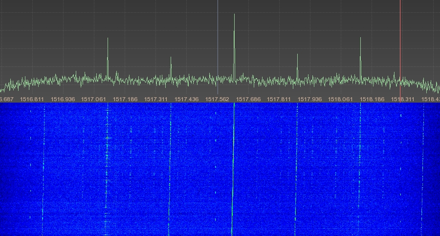
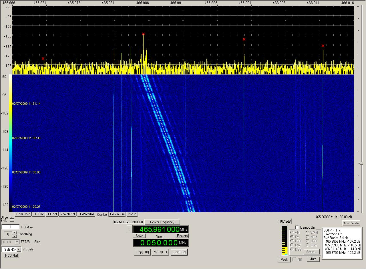
 Paul
M0YET detected an additional downlink signal on 465.99
MHz using the modulation: 400 bps HDLC, Bi-phase-L,
PM . It comes from the ARGOS-3 A-DCS system. He recorded
the spectrum plot on Feb 7th 2009 at 11:30h UTC. Paul
M0YET detected an additional downlink signal on 465.99
MHz using the modulation: 400 bps HDLC, Bi-phase-L,
PM . It comes from the ARGOS-3 A-DCS system. He recorded
the spectrum plot on Feb 7th 2009 at 11:30h UTC.
|
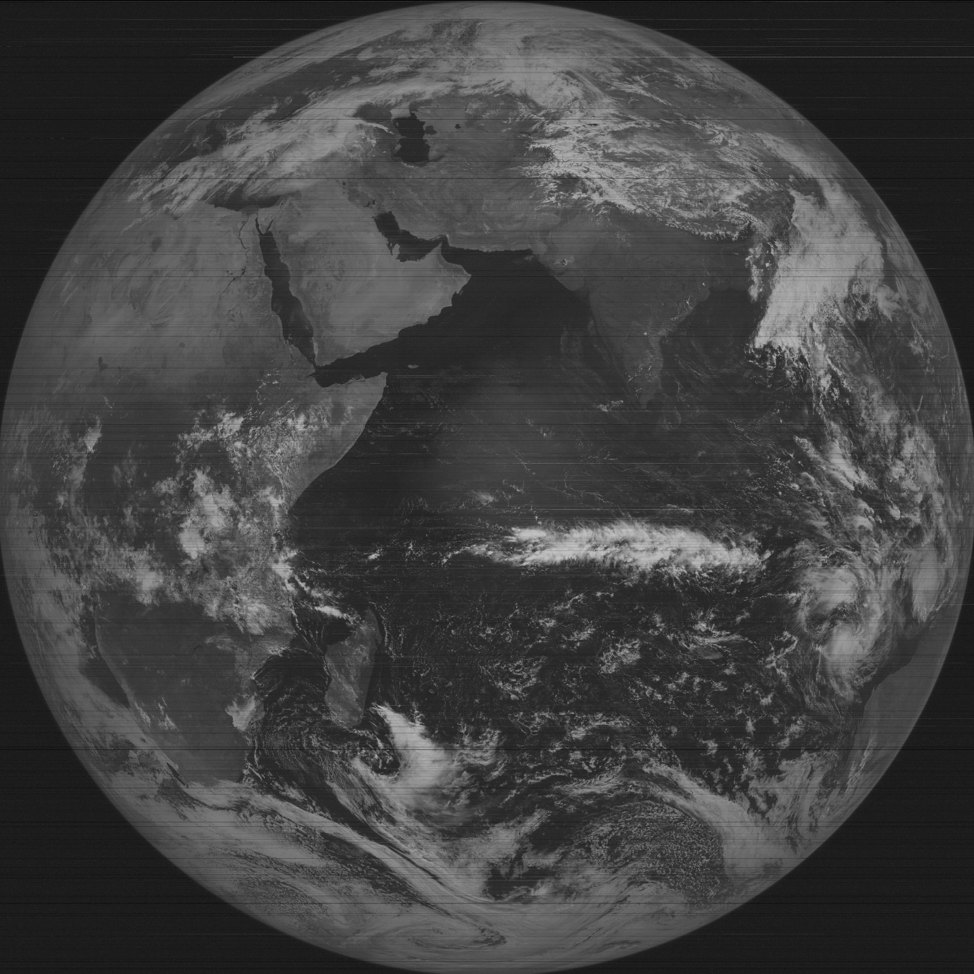
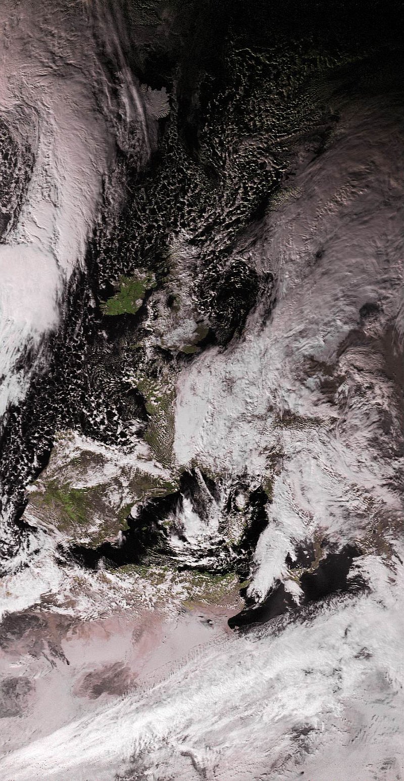
 This
sound file and the associated APT picture shown on the
right were received by Mike DK3WN on Feb 7th
2009 around 13:15UTC on 137.9125 MHz. This
sound file and the associated APT picture shown on the
right were received by Mike DK3WN on Feb 7th
2009 around 13:15UTC on 137.9125 MHz.
|
 Mike
Kenny in Australia received APT signals of NOAA 19 during
north-bound passes in the Southern Hemisphere. The audio
file was recorded on February 8th
2009 at 04:03UTC. The picture was recorded on February
7th 2009 at 04:07UTC. Mike
Kenny in Australia received APT signals of NOAA 19 during
north-bound passes in the Southern Hemisphere. The audio
file was recorded on February 8th
2009 at 04:03UTC. The picture was recorded on February
7th 2009 at 04:07UTC. |
 Enclosed
excellent picture from NOAA 19 was received on April
17th 2011 at 13:14 UTC by DG3IX.
Kindly provided by Thomas DG3IX. Enclosed
excellent picture from NOAA 19 was received on April
17th 2011 at 13:14 UTC by DG3IX.
Kindly provided by Thomas DG3IX.
|
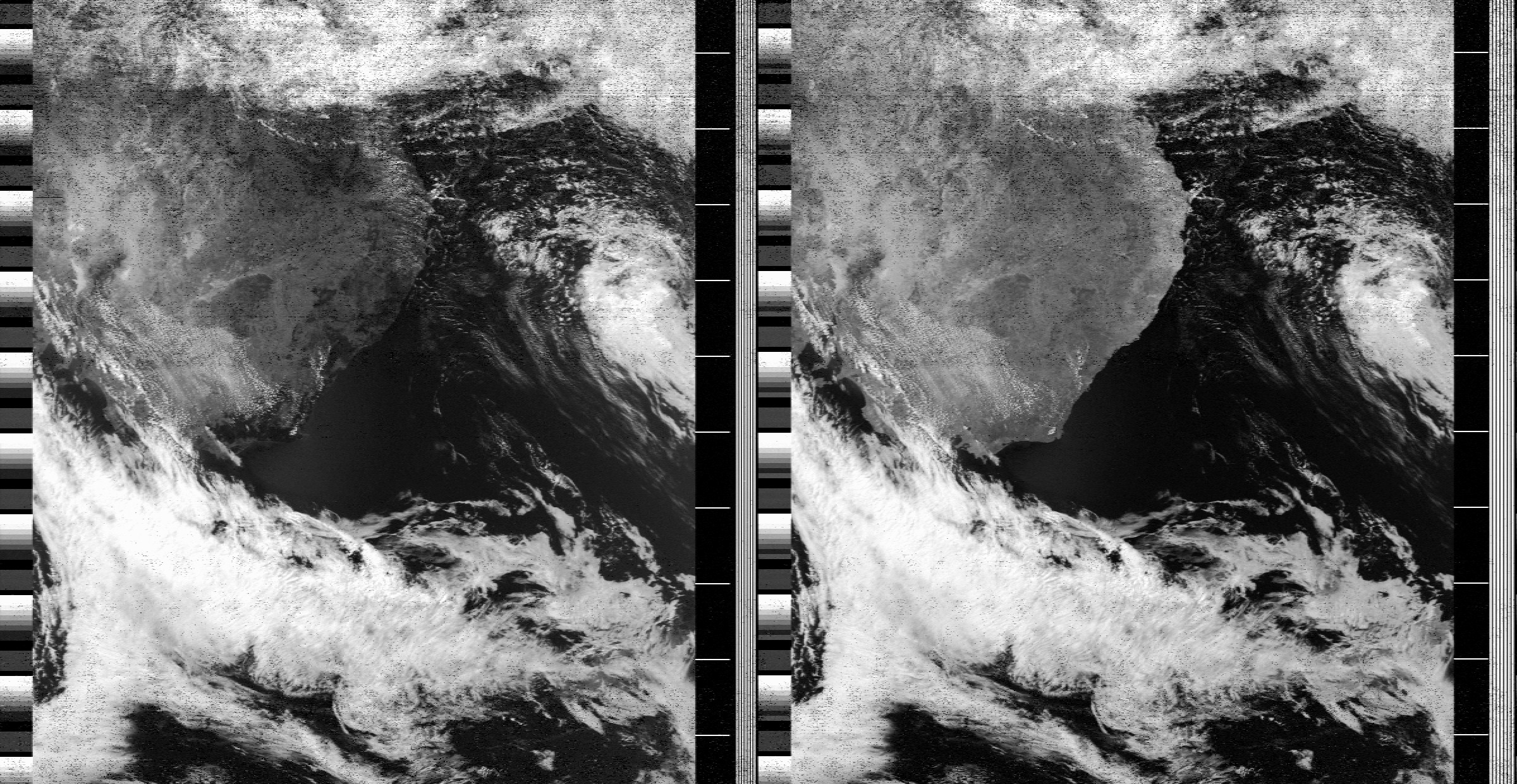
 During
my summer vacation 2011 I received NOAA 19 multiple
times. You can find a number of pictures following the
link associated with the picture to the right. Here
is a sound file recorded on 137.100 MHz on August 21st
2011 at 11:04 UTC by DD1US. During
my summer vacation 2011 I received NOAA 19 multiple
times. You can find a number of pictures following the
link associated with the picture to the right. Here
is a sound file recorded on 137.100 MHz on August 21st
2011 at 11:04 UTC by DD1US.
|
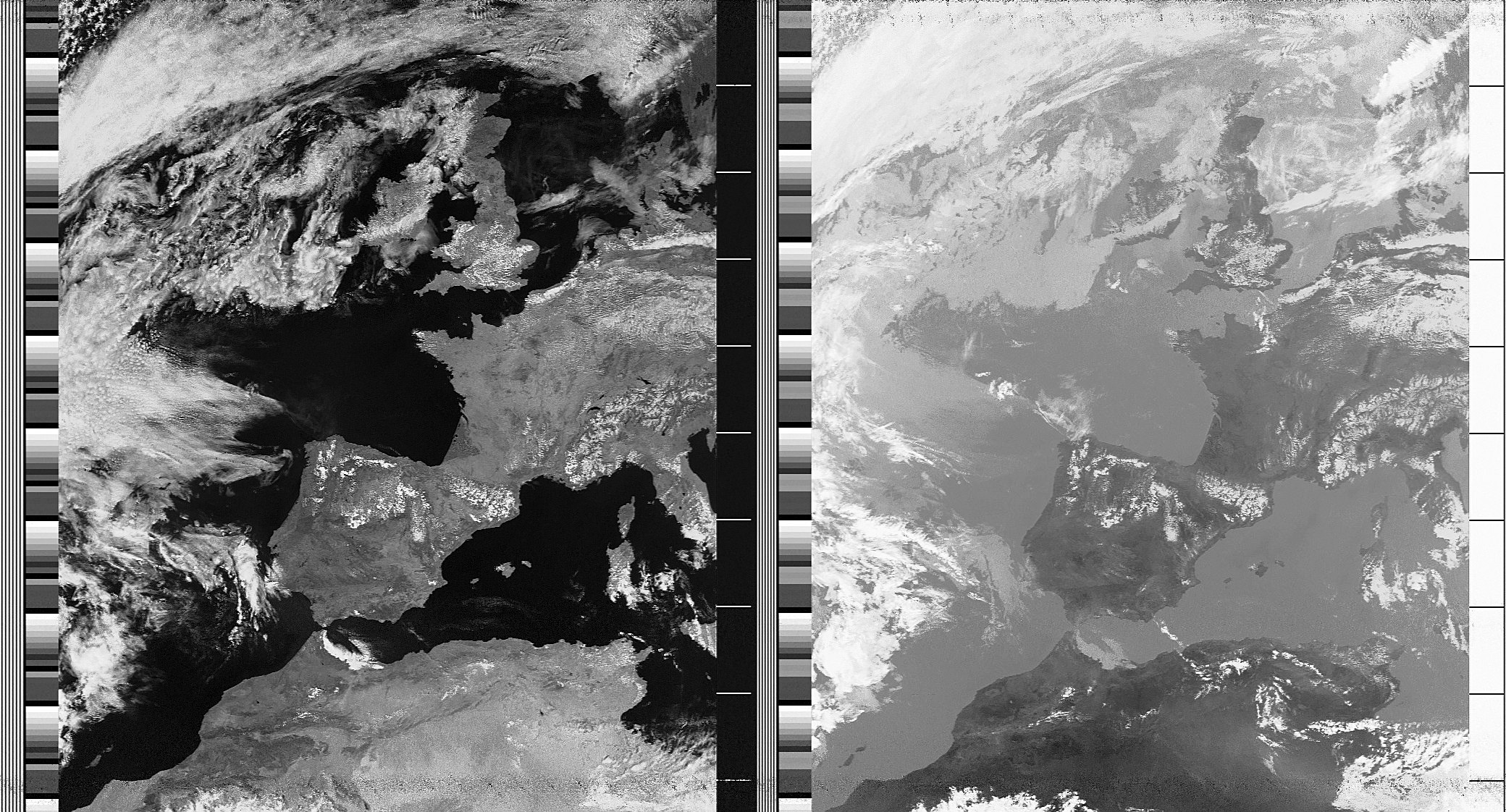
 Also in
2012 NOAA-19 was transmitting excellent pictures like
the one enclosed. NOAA-19 was received on 137.100 MHz
in FM on May 6th 2012 at 11:11
UTC by DD1US. Also in
2012 NOAA-19 was transmitting excellent pictures like
the one enclosed. NOAA-19 was received on 137.100 MHz
in FM on May 6th 2012 at 11:11
UTC by DD1US.
|
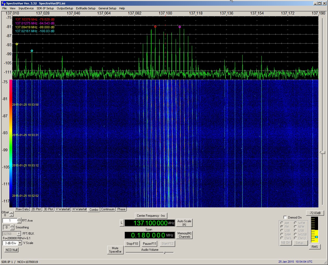
 In
January 2015 NOAA-19 continued to transmit excellent
pictures. Enclosed spectrum plot was received on 137.100
MHz in FM on January 25th 2015
at 10:54 UTC by DD1US. In
January 2015 NOAA-19 continued to transmit excellent
pictures. Enclosed spectrum plot was received on 137.100
MHz in FM on January 25th 2015
at 10:54 UTC by DD1US.
|

|
GOCE
Earth Explorer 1
#34602
(2009-013A) |
GOCE (Gravity field and
steady-state Ocean Circulation Explorer) was a European
(ESA) Earth science satellite designed to measure Earth's
gravitational field to create very high-resolution maps
of the geoid. These maps were to provide the baseline
for measurements of ocean circulation and sea-level
change.
The 1050 kg spacecraft was 5 m long
by 1 m wide with fixed solar arrays producing 1.3 kW
of power. The satellite carried six high-sensitivity
accelerometers arranged along three axes of the spacecraft.
To enable the satellite to acquire high-resolution measurements
the satellite traveled at a low orbital altitude (260
km) at which atmospheric drag effects are still significant.
To compensate for these effects the satellite had a
sleek arrow-shaped design to reduce drag and small winglets
and a tail fin to stabilize the spacecraft. GOCE's orbital
altitude was maintained with the assistance of an ion
engine on-board.
GOCE that was launched on March 17th
2009 at 14:21 TUC from Plesetsk on a Rockot/Breeze KM
launch vehicle. The GOCE satellite re-entered the Earth's
atmosphere shortly before midnight UTC on November 10th
2013 after finally running out of fuel. |
March
17th 2009 |
1100
kg |
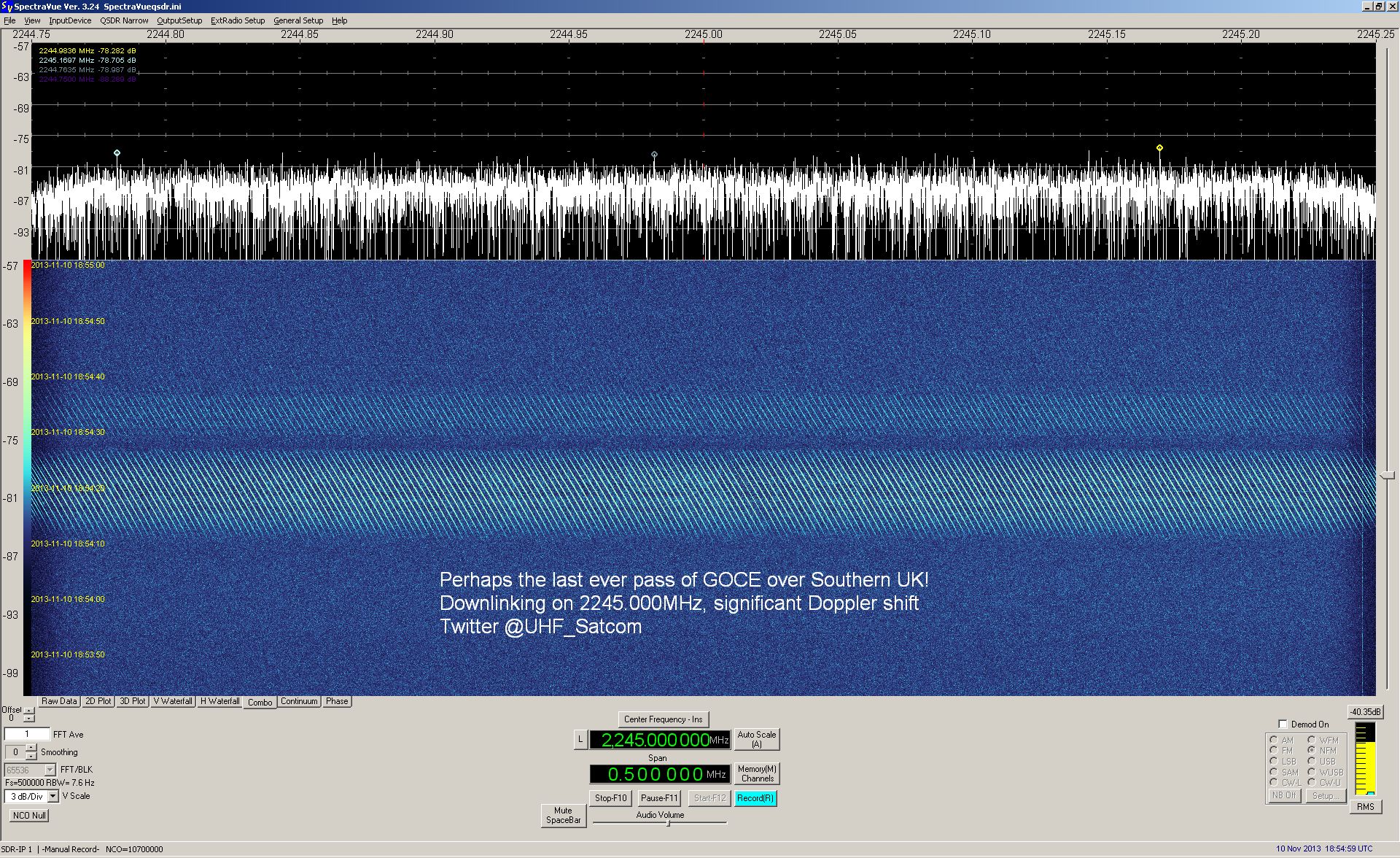
 The
S-band downlink signal of GOCE at 2245 MHz was received
by M0EYT in the early evening of November 10th
2013 at 18:54 UTC, only a few hours before the re-entry
of the satellite. The spectrum plot was kindly provided
by Paul Marsh M0EYT. The
S-band downlink signal of GOCE at 2245 MHz was received
by M0EYT in the early evening of November 10th
2013 at 18:54 UTC, only a few hours before the re-entry
of the satellite. The spectrum plot was kindly provided
by Paul Marsh M0EYT.
|

|
Yaogan-6
YG 6
JianBing 7
JB-7 1
#34839
(2009-021A) |
Yaogan 6 is a remote
sensing satellite launched on a Long March 2C rocket
from the
Taiyuan Satellite Launch Center in China's north Shanxi
Province
into a 520 km high LEO. |
Apr
22nd 2009 |
xx
kg |
 The
S-Band downlink on 2296.52 MHz of Yaogan-6 was received
and enclosed FFT plot was generated between March and
May 2014 by Milen Rangelov. The
S-Band downlink on 2296.52 MHz of Yaogan-6 was received
and enclosed FFT plot was generated between March and
May 2014 by Milen Rangelov.
|

|
PharmaSat-1
#35002
(2009-028B) |
PharmaSat-1
is s a follow on to the highly successful GeneSat-1
Mission. The Ames Small Spacecraft Division is collaborating
with industry and local universities to develop the
next generation fully-automated, miniaturized triple
cubesat spaceflight system for biological payloads.
The PharmaSat experiment and flight system are designed
to measure the influence of microgravity upon yeast
resistance to an antifungal agent. PharmaSat implements
PI guided science focused on questions key to countermeasure
development for long-term space travel and habitation.
It uses a FM 1k2 AFSK AX.25 communications downlink
at 437.465 MHz. Received by Mike DK3WN on May 21st
2009 at 16:25 UTC. |
May 19th
2009 |
5 kg |


|
HawkSat-1
#35003
(2009-028C) |
HawkSat-1
is a single-unit Cubesat which was built and will be
operated by the Hawk Institute for Space Science. It
is based on a CubeSat kit from Pumpkin Incorporated
and carries a technology demonstration payload, primarily
as a proof-of-concept mission, testing command, data
and power subsystems. It is powered by solar cells.
Experimental data will be returned to Earth by means
of a store and dump communications systems. The downlink
frequency is 437.345 MHz. |
May 19th
2009 |
1 kg |

|
PolySat
CP6
#35004
(2009-028D) |
CP6 was
built at California Polytechnic State University at
San Luis Obispo. Its primary mission is to implement
an attitude control system using only magnetic torquers
embedded within the side panels. Attitude determination
is performed using two-axis magnetometers on each side
panel as well as observation imagers on the payload
face. Once the primary objectives have been met, a command
will be sent to deploy the secondary payload that consists
of a series of spring steel tapes supporting an electron
collection experiment provided by Naval Research Laboratory.
CP6 uses two FM 1k2 AFSK AX.25 communications downlinks
with transmit power of 1 W. The estimated center frequencies
of the alternating transmitters (several burst COMM
A, then COMM B) are COMM A = 437.3655 MHz and COMM B
= 437.3664 MHz. Received by Mike DK3WN on May 20th
2009 at 17:59 UTC. |
May
19th 2009 |
1
kg |
Enclosed
signal was recorded on July 31st
2009 at 08:45 UTC by Mike DK3WN. |

|
Meridian
2
Meridian 12 L
14F112
#35008
(2009-029A) |
Meridian 2 is a Russian
military/government communications satellite launched
on a Soyuz 2-1a rocket with a Fregat upper stage from
Plesetsk, Russia. Meridian combines the military and
civilian tasks of the former Molniya-1 and Molniya-3
satellites, together with the clandestine communications
function of the outgoing LEO Parus satellites. Meridian
2 did not reach its target orbit which is a highly elliptical
orbit (HEO) with an inclination of 63°, also called
Molniya orbit. Nevertheless Meridian 2 is operational.
Meridian 2 has multiple transponders:
P-Band downlink:
277.4 - 278.4 MHz,
UHF-Band downlink: 484.0 MHz
38 kHz wide,
C-Band downlink: approx. 3600 MHz. |
May
21st 2009 |
>
2000 kg |
Paul Marsh
received on the C-Band downlink at 3610 MHz a low data
rate FSK signal of Meridian 2 on January 2nd
2015 at 16:47 UTC. Audio recording kindly provided by
Paul Marsh M0EYT. |

|
UK-DMC
2
DMC-2
#35683
(2009-041C) |
DMC 2, a UK remote
sensing satellite also known as UK-DMC 2, was launched
on a Dnepr rocket from Baikonur. The satellite gathers
wide-angle, medium-resolution images. DMC 2 joined the
international Disaster Monitoring Constellation (DMC),
a fleet of small Earth-watching satellites designed
to provide quick-response imagery to emergency managers
worldwide. DMC images are also used for mapping, urban
planning, and resource management. |
July
29th 2009 |
97
kg |
 The
S-Band downlink on 2233.33 MHz of UK-DMC 2 was received
and enclosed FFT plot was generated in May 2014 by Milen
Rangelov. The
S-Band downlink on 2233.33 MHz of UK-DMC 2 was received
and enclosed FFT plot was generated in May 2014 by Milen
Rangelov.
|

|
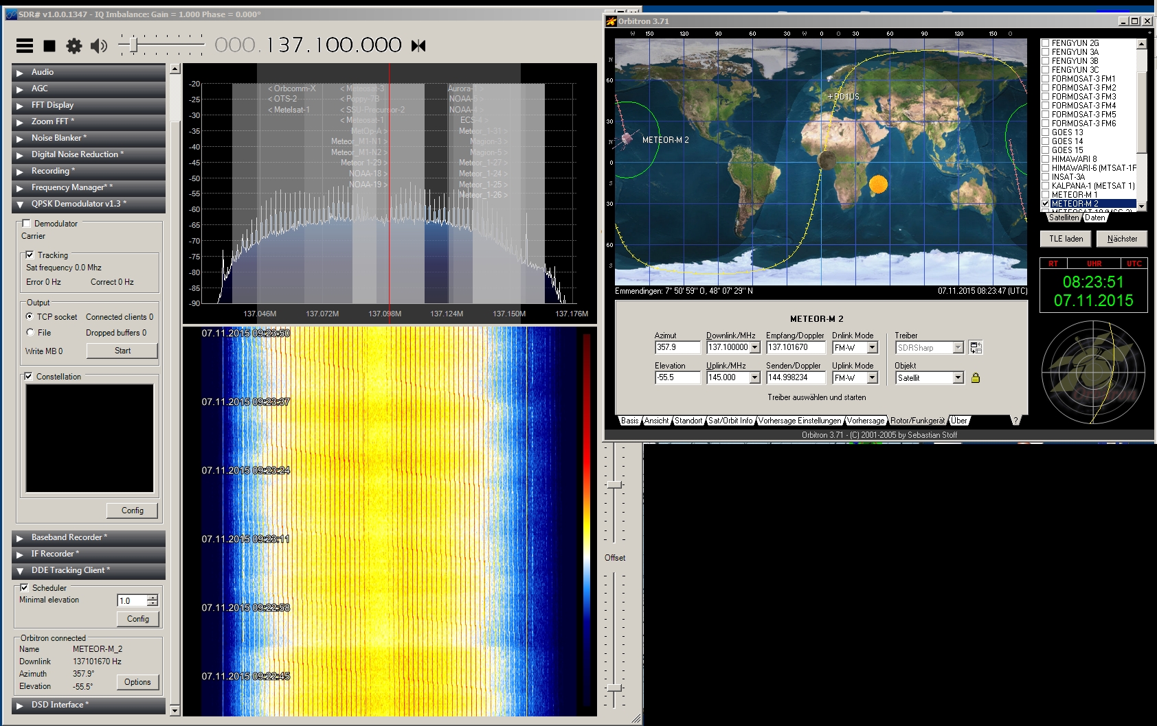
Meteor
M1
Meteor-M-1
#35865
(2009-049A) |
Meteor M1 is a Russian
weather satellite launched on a Soyuz 2 (#7) rocket
from Baikonur into a 840 km sun-synchronous orbit. This
new generation of weather satellites features digital
VHF transmissions (LRPT) instead of the traditional
analog APT transmissions. The downlink frequency is
137.100 MHz.
|
Sept
17th 2009 |
2755
kg |
Enclosed
signal was recorded on Dec. 19th
2009 at 20:10 UTC by Mike DK3WN. |
On May 28th
2013 Meteor M1 changed frequency from 137.100 MHZ to
137.900 MHz. Simultaneously the LRPT mode was switched
from 72 kbps QPSK to 80 kbps Unique Word QPSK. |
 On
November 7th 2015 at 08:25
UTC enclosed strong signal from Meteor M1 was received
on 137.096 MHz. Received and recorded by DD1US. On
November 7th 2015 at 08:25
UTC enclosed strong signal from Meteor M1 was received
on 137.096 MHz. Received and recorded by DD1US.
|
 On
the same day on November 7th 2015 at 14:27 UTC Luc VE2FXL
received and decoded a picture of Meteor-M-1 also on
137.096 MHz. The datarate is 80kbps. Pictures kindly
provided by Luc VE2FXL. On
the same day on November 7th 2015 at 14:27 UTC Luc VE2FXL
received and decoded a picture of Meteor-M-1 also on
137.096 MHz. The datarate is 80kbps. Pictures kindly
provided by Luc VE2FXL.
|
 On
January 1st 2020 Egor UB1QBJ
received the HRPT downlink signal from Meteor M1. Picture
kindly provided by Egor UB1QBJ. On
January 1st 2020 Egor UB1QBJ
received the HRPT downlink signal from Meteor M1. Picture
kindly provided by Egor UB1QBJ.
|

|
UGATUSAT
RS-28
#35868
(2009-049D) |
Ugatusat
(Ufimskiy Gosudarstvenniy Aviatsionniy Tekhnicheskiy
Universitet Satellite) is a remote sensing and educational
satellite developed by Ugatu (Ufa State Aviation Technical
University) and built by PO Polyot. It features a camera
with a resolution of 50m. Ugatusat was launched on a
Soyuz 2 (#7) rocket into a 823km circular orbit with
an inclination of 98.8°. Ugatusat failed end of
2009. |
Sept
17th 2009 |
35
kg |
Ugatusat
transmitted CW on 435.264 MHz using the callsign RS-28.
Enclosed CW beacon signal was recorded on Sept. 27th
2009 at 19:00 UTC by Mike DK3WN. |


|
Tatyana-2
Tatiana-2
Universitetsky 2
RS-38
#35869
(2009-049E) |
Tatyana-2
is a small (100kg) international research and educational
satellite built under the lead of Moscow State University
(MGU) in cooperation with Ewha Womans University (EWU)
in Seoul, Korea, Seoul National University, Pusan (Korea)
National University and University of Puebla (BUAP),
Mexico.
The satellite is 3 axis stabilized and
has 3 scientific mission objectives:
1.) to investigate
light phenomena in the Earths atmosphere due to the
effect of galaxy cosmic rays and high-energy charged
particles
2.) to investigate en-route radiation
conditions
3.) to investigate variations of the
Earths gravitational and magnetic fields.
Its reported
downlink frequencies are:
- VHF (145 MHz for 1.2
kbit/s TT&C data),
- UHF (435.440 MHz and 435.490
MHz for onboard systems telemetry CW abd 9.6 kbit/s
DOKA)
- L-band (1.708 GHz 665.4kbit/s for scientific
telemetry). Tatyana uses the callsign RS-38 for its
CW transmissions on 435.490 MHz. |
Sept
17th 2009 |
98
kg |
The CW
downlink of RS-38 on 435.490 MHz was recorded on December
30th at 09:30 UTC by DD1US.
The first part of the 5 min recording was demodulated
in CW mode, the last part in NFM mode. |

|
SwissCube
#35932
(2009-051B) |
SwissCube
is the first satellite entirely built in Switzerland.
This 10x10x10cm Cubesat was mainly built by more than
180 students from different universities under the supervision
of the Swiss Space Center EPFL in Lausanne. It was launched
via the PSLV (Polar Satellite Launch Vehicle) from Satish
Dhawan Space Center in India. It contains a Ham Radio
downlink transmitting on 437.505 MHz using the callsign
HB9EG/1. Enclosed CW beacon signal was recorded on Sept.
25th 2009 at 11:06 UTC by Mike
DK3WN. |
Sept
23rd 2009 |
1
kg |
Enclosed
CW beacon signal was recorded on Sept. 26th
2009 at 11:56 UTC by Mike DK3WN. |
Enclosed
recording of the 1200bd BPSK downlink signal was kindly
provided by Mike DK3WN. |
On January
6th 2015 at 14:13 UTC Francisco
EA7ADI received the CW signal of SwissCube. Recording
kindly provided by Francisco EA7ADI. |

|
UWE-2
#35933
(2009-051C) |
UWE-2 is
the second cubesat built by the University of Wuerzburg
in Germany. It was launched via the PSLV (Polar Satellite
Launch Vehicle) from Satish Dhawan Space Center in India.
The published downlink is 437.385 MHz (FSK, 1k2 AFSK
/ 9k6 FSK AX.25) with a transmit power of 0.5W. |
Sept
23rd 2009 |
1
kg |
Enclosed
1k2 AFSK packet radio downlink signal was recorded on
Sept 25th 2009 at 12:44 UTC
by Mike DK3WN. Please note that the long pauses between
the packets were removed to reduce the file size. |

|
BeeSat
#35934
(2009-051D) |
BeeSat is a 10x10x10cm
Cubesat built by the University of Berlin. It was launched
via the PSLV (Polar Satellite Launch Vehicle) from Satish
Dhawan Space Center in India. It contains a Ham Radio
downlink transmitting with 100mW output power on 436.0
MHz. Signals are either CW or 4k8/9k6 GMSK telemetry
both using the callsign DP0BEE. Beesat is not using
AX.25 format but Mobitex format. The used modem is a
CMX909B(CML). |
Sept
23rd 2009 |
1
kg |
Enclosed
signal was recorded on Oct. 21st
2009 by Mike DK3WN. |
Enclosed
CW beacon signal was recorded on Oct. 21st
2009 by Mike DK3WN. |

|
ITUpSat1
ITUPSAT-1
#35935
(2009-051E) |
ITUpSAT1
is the first cubesat / picosat built by Technical University
Istambul in Turkey. It was launched via the PSLV (Polar
Satellite Launch Vehicle) from Satish Dhawan Space Center
in India. Enclosed CW signal from ITUpSat was received
on 437.325 MHz by Mike DK3WN. |
Sept
23rd 2009 |
1
kg |
On October
15th 2014 at 16:37 UTC Francisco
EA7ADI received the CW signal of ITUPSAT-1. Recording
kindly provided by Francisco EA7ADI. |
Also on
May 6th 2015 at 15:45 UTC Francisco
EA7ADI received the CW signal of ITUPSAT-1. Recording
kindly provided by Francisco EA7ADI. |

|
DMSP
F-18
DMSP 5D-3/F18
USA210
#35951
(2009-057A) |
DMSP-F18, also known
as DMSP 5D-3 F18 or USA 210, is a US Department of Defense
weather satellite launched on an Atlas 5 rocket from
Vandenberg into a 850km high sun-synchronous orbit.
The 1,200 kg satellite, one of several in the Defense
Meteorological Satellite Program, will provide terrestrial
and space weather data from a near-polar, Sun-synchronous,
830 km altitude orbit. The DMSP satellites monitor the
meteorological, oceanographic and solar-terrestrial
physics environments. The primary weather sensor on
DMSP is the Operational Linescan System, which provides
continuous visual and infrared imagery of cloud cover.
Additional satellite sensors measure atmospheric vertical
profiles of moisture and temperature. DMSP satellites
also measure space environmental parameters such as
local charged particles and electromagnetic fields. |
Oct
18th 2009 |
1200
kg |
 The
S-Band downlink on 2222.5 MHz of DMSP F-18 was received
and enclosed FFT plot was generated in April 2014 by
Milen Rangelov. The
S-Band downlink on 2222.5 MHz of DMSP F-18 was received
and enclosed FFT plot was generated in April 2014 by
Milen Rangelov.
|
 The
S-Band wideband downlink on 2252.5 MHz of DMSP F-18
was received and enclosed FFT plot was generated in
April 2014 by Milen Rangelov. The
S-Band wideband downlink on 2252.5 MHz of DMSP F-18
was received and enclosed FFT plot was generated in
April 2014 by Milen Rangelov.
|


|
PROBA
2
#36037
(2009-059B) |
PROBA-2
(Project for On-Board Autonomy)
was launched on Nov 2nd 2009
as a secondary payload together with the SMOS mission
into a 700 km sun-synchronous orbit. PROBA-V is operated
by ESA (European Space Agency). Its objectives are in-orbit
demonstration and evaluation of new hard- and software
for spacecraft technologies and for on-board operational
autonomy as well as in-orbit trial and demonstration
of sun observation and space environment instruments.
|
Nov
2nd 2009 |
130
kg |
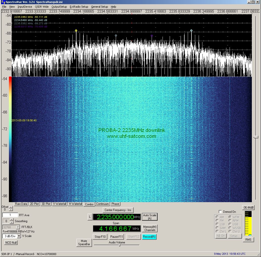
 PROBA
2 has an S-band 2 Mbit/s BPSK downlink at 2235 MHz which
was received on May 9th 2013
at 19:56 UTC. The spectrum plot was kindly provided
by Paul Marsh M0EYT. PROBA
2 has an S-band 2 Mbit/s BPSK downlink at 2235 MHz which
was received on May 9th 2013
at 19:56 UTC. The spectrum plot was kindly provided
by Paul Marsh M0EYT.
|
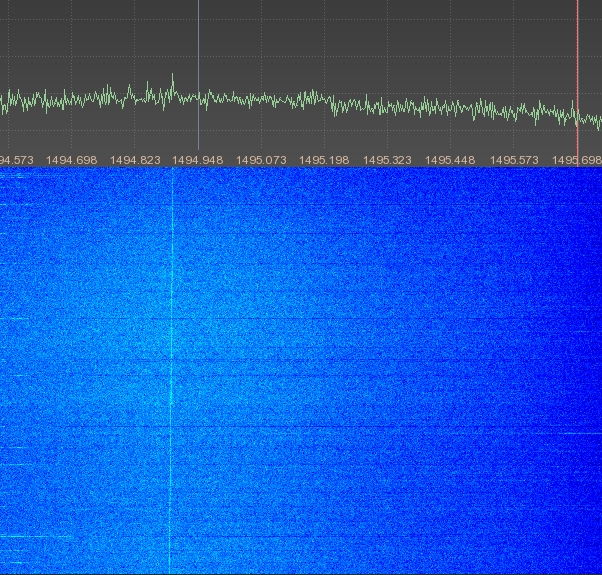
 The
S-Band downlink on 2235 MHz of Proba-2 was received
and enclosed FFT plot was generated in May 2014 by Milen
Rangelov. The
S-Band downlink on 2235 MHz of Proba-2 was received
and enclosed FFT plot was generated in May 2014 by Milen
Rangelov.
|

|
COSMO-Skymed
4
SKYMED 4
#37216
(2010-016A) |
COSMO-SkyMed 4 is
an Italian Earth-imaging Synthetic Aperture Radar that
was launched by a Delta 2 rocket from Vandenberg AFB.
COSMO is the abbreviation of COnstellation of
small Satellites for the Mediterranean basin Observation.
It
is a dual use satellite (civilian and military use).
The 1.7 ton, 3.6 kW craft is the second of a four-satellite
constellation, and carries an X-band (9.6 GHz) radar.
The swath width is variable and provides images at a
resolution between 1 to 100 meters (in civilian mode).
|
Nov
6th 2010 |
1700
kg |
 The
S-Band downlink on 2230 MHz of SKYMED 4 was received
and enclosed FFT plot was generated in May 2014 by Milen
Rangelov. The
S-Band downlink on 2230 MHz of SKYMED 4 was received
and enclosed FFT plot was generated in May 2014 by Milen
Rangelov.
|


|
PRISMA
#36599
(2010-028B) |
PRISMA (Prototype Research
Instruments and Space Mission Advancement) was launched
on a Dnepr rocket from the Dombarovsky Missile Base,
Russia into a sun-synchronous orbit with an altitude
of 710 km. PRISMA actually consists of two satellites,
nicknamed Mango and Tango, which separated in space
and test technologies and rendezvous and formation flying
in space. Mango (140 kg main satellite) and Tango (40
kg target satellite) are communicating via an ISL (inter
satellite link) operating at 400.550 MHz using FSK modulation.
|
June
15th 2010 |
180
kg |
Enclosed
recording of the signals of the 2 satellites was done
on August 16th 2010 at 06:22
UTC by DD1US. Because of the used CW demodulation you
can hear the longer pulsed signal from Tango (880ms)
and the shorter pulsed signal from Mango (300ms) with
a slight frequency offset (pitch). |
These
recordings were made on August 16th
2010 at 16:45 UTC on 400.550 MHz by DD1US. The first
part was recorded using a NFM demodulator (the bandwidth
was only 10 kHz and should have been 20 kHz), the second
part was recorded in CW. |
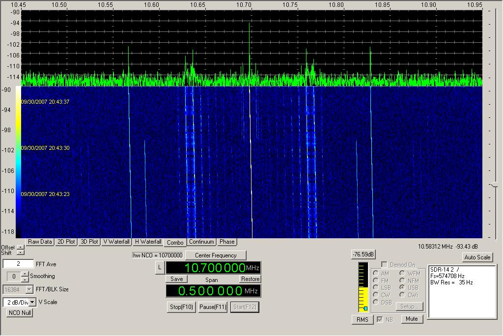
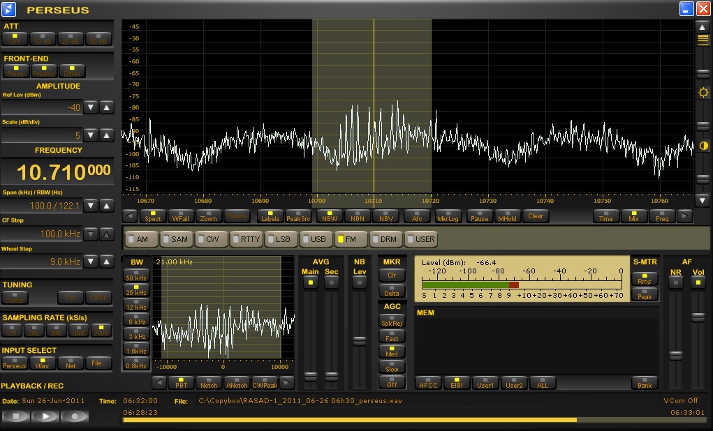
Finally I received Prisma
once more on that same day  August
16th 2010 at 20:05 UTC and
created enclosed waterfall plot with a Perseus SDR connected
to the 10.7 MHz IF output of my receiver. You can see
the longer transmission from Tango and the shorter transmission
from Mango. August
16th 2010 at 20:05 UTC and
created enclosed waterfall plot with a Perseus SDR connected
to the 10.7 MHz IF output of my receiver. You can see
the longer transmission from Tango and the shorter transmission
from Mango. |


|
IRS-2B
Cartosat-2B
#36795
(2010-035A) |
Cartosat 2B, an
Indian Earth observation satellite, was launched from
Sriharikota by a Polar Satellite Launch Vehicle. The
satellite carries a panchromatic, high spatial resolution,
stereoscopic vision camera. The satellite's black and
white camera has a resolution of 0.8 m and observea
Earth land and ocean surfaces from orbit. The imagery
has applications in resource mapping, urban planning,
transportation studies, water monitoring, and crop inventories. |
Jul
12th 2010 |
694
kg |
 The
S-Band downlink on 2245.7 MHz of IRS-2B was received
and enclosed FFT plot was generated between March and
May 2014 by Milen Rangelov. The
S-Band downlink on 2245.7 MHz of IRS-2B was received
and enclosed FFT plot was generated between March and
May 2014 by Milen Rangelov.
|
|
COSMOS
2467
KOSMOS 2467
Strela-3 #142
#37152
(2010-043A) |
Three Russian communication
satellites, two Cosmos military satellites and a Gonets
civilian communication satellite, were launched on September
8th 2010 from Plesetsk at 03:30
UT by a Rokot launcher. The Gonets satellite is designed
to store and relay personal messages. |
Sept.
8th 2010 |
200
kg |
 COSMOS
2467 was received by Roland Proesch DF3LZ on October
11th 2013 at 23:18 UTC on 261.0350
MHz in USB. Sound file kindly provided by Roland Proesch
DF3LZ. COSMOS
2467 was received by Roland Proesch DF3LZ on October
11th 2013 at 23:18 UTC on 261.0350
MHz in USB. Sound file kindly provided by Roland Proesch
DF3LZ.
|

|
Zhead
Pixing 1B
Zheda Pixing 1A-1
#37166
(2010-047B) |
The Chinese picosats
Zheda Pixing 1B and Zheda Pixing 1C were launched on
September 22nd 2010
from Jiuquan on a Long March 2D rocket. They were developed
by Zhejiang University for microelectronics studies
to provide a testbed in near-Earth space for MEMS devices,
such as an accelerometer, micro-gyros and infrared sensors. |
Sep.
22nd 2010 |
3.5
kg |
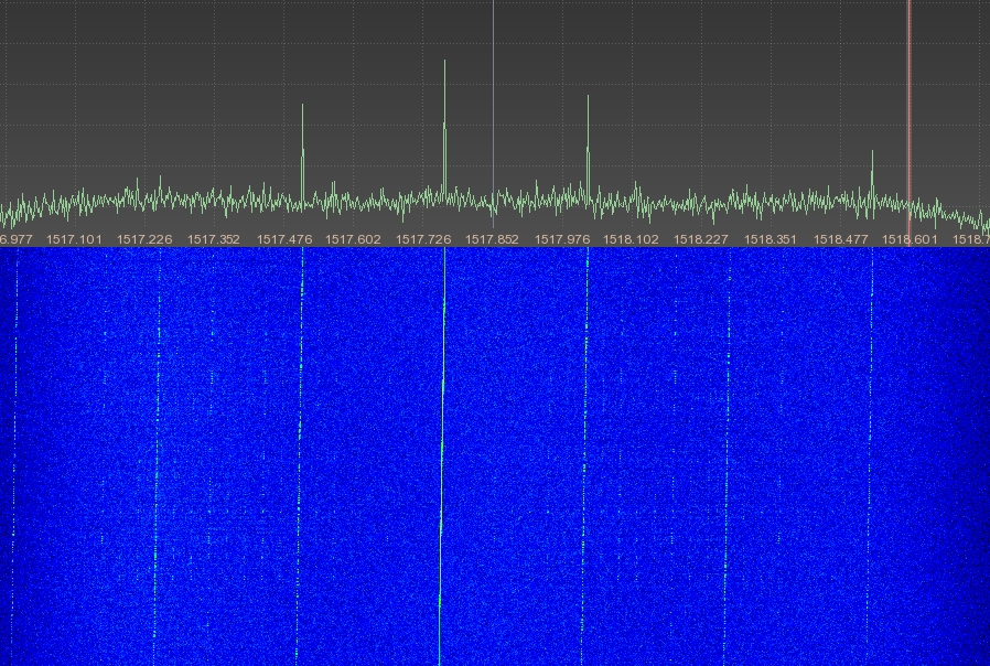
 The
S-Band downlink on 2285.525 MHz of Pleiades 1 was received
and enclosed FFT plot was generated in June 2014 by
Milen Rangelov. The
S-Band downlink on 2285.525 MHz of Pleiades 1 was received
and enclosed FFT plot was generated in June 2014 by
Milen Rangelov.
|
|
Meridian
3
Meridian 13 L
#37212
(2010-058A) |
Meridian 3 is a Russian
military/government communications satellite launched
on a Soyuz 2-1a rocket with a Fregat upper stage from
Plesetsk, Russia. Meridian combines the military and
civilian tasks of the former Molniya-1 and Molniya-3
satellites, together with the clandestine communications
function of the outgoing LEO Parus satellites. Meridian
3 has a highly elliptical orbit (HEO) with an inclination
of 63°, also called Molniya orbit. Meridian 3 has
multiple transponders:
P-Band downlink: approx.
278 MHz 1 MHz wide (unconfirmed),
UHF-Band downlink:
483.745 MHz 38 kHz wide,
C-Band downlink: approx.
3600 MHz. |
Nov.
2nd 2010 |
>
2000 kg |
Paul Marsh
received on the C-Band downlink at 3610 MHz a low data
rate FSK signal of Meridian 3 on January 2nd
2015 at 16:42 UTC. Audio recording kindly provided by
Paul Marsh M0EYT. |

|
STPSat-2
USA 217
#37222
(2010-062A) |
STPSat-2 is an experimental
spacecraft built by xxx for STP (Space Test Program)
of DoD (department of defense). It was launched by a
Minotaur-4 rocket into a circular orbit (641kmx652km)
with 72 degrees inclination. It carries 3 main experiments:
two experiments evaluate sensor compatibility in space
environment and are called SPEX (Space Phenomenology
Experiment). The third experiment is called ODTML (Ocean
Data Telemetry MicroSatLink) and here STPSat-2 acts
as a two way data relay between terrestrial (ocean or
land) sensors and users
In May
2012 Maik Hermenau received an unidentified signal on
400.180 MHz which in the course of summer he finally
identified to be from USA-217. Enclosed recording of
STPSat-2 was received, recorded and kindly provided
by Maik Hermenau. |
Nov 20th
2010 |
180 kg |


|
RAX
USA 218
#37223
(2010-062B) |
RAX (Radio Aurora Explorer)
is a joint venture between the University of Michigan
and SRI International. Its primary mission objective
is to study large plasma formations in the ionosphere,
the highest region of our atmosphere. This science spacecraft
was developed by over 40 students (undergraduate through
graduate), six professional engineers, and one Michigan
professor in just two years time. RAX is a standard
3U CubeSat that is 10 cm x 10 cm x 34 cm in size and
2.8 kg in mass.
RAX was launched on November 20th
2010 at 01:25 UTC from the Kodiak Launch Complex in
Kodiak, Alaska aboard a Minotaur IV rocket into a 650km
circular orbit.
The radio payload includes a bistatic
radar receiver (426-512 MHz), a GPS receiver, a 2.4
GHz 115kbps GMSK transceiver and a UHF 38.4kbps transceiver
which is also used for the Amateur Radio telemetry downlink.
This downlink at 437.505 MHz uses GMSK modulation to
broadcast a 9600bd data downlink signal ever 20 seconds.
The callsign used is RAX-1. The downlink transmit power
is 750 mW and the polarization used is RHCP. |
Nov
20th 2010 |
2.8
kg |
Mike DK3WN was first
in receiving and successfully decoding RAX on November
20th 2010 at 04:20 UTC. |
Mike DK3WN
received and decoded enclosed 9k6 downlink signal from
RAX on November 21st 2010 on
437.505 MHz. The 9k6 transmission burst sound like "noise"
to our ear but you can recognize them when the "noise"
gets lower volume. The pauses between the bursts were
shortened in enclosed recording. Recording kindly provided
by Mike DK3WN. |


|
O/OREOS
USA 219
#37224
(2010-062C) |
Organism/Organic Exposure
to Orbital Stresses (O/OREOS) is a nanosatellite based
on a 3U cubesat structure.
The goal of the O/OREOS
mission is to be able to conduct low-cost astrobiology
science experiments on autonomous nanosatellites in
space.
O/OREOS was launched together with RAX on
November 20th 2010 at 01:25
UTC from Kodiak Launch Complex in Kodiak, Alaska aboard
a Minotaur IV rocket.
It features a 1200bd AX.25
AFSK downlink at 437.505 MHz which transmits every 5
seconds using the callsign KF6JBP. |
Nov
20th 2010 |
5.5
kg |
Mike
DK3WN received the 1k2 AFSK downlink signal on November
20th 2010 at 04:20 UTC. He
was first providing decoded data to the O/OREOS team
in USA. Recording kindly provided by Mike DK3WN. |
Also Henk
PA3GUO was able to receive and decode the 1200bd downlink
signal at 437.505 MHz on November 20th
at 06:00 UTC. Enclosed recording was kindly provided
by Henk PA3GUO. |
On May
7th 2015 at 18:21 UTC Francisco
EA7ADI received the AFSK signal of O/OREOS. Recording
kindly provided by Francisco EA7ADI. |
On May
14th 2015 at 17:18 UTC Francisco
EA7ADI received the AFSK signal of O/OREOS again. Recording
kindly provided by Francisco EA7ADI. |

|
FASTSAT
FASTSAT-HSV 01
USA 220
#37225
(2010-062D) |
Another satellite
launched on the same rocket on November 20th
2010 was FastSat (Fast Affordable Scientific and Technology
Satellite) which is a small technological low cost satellite
built by the "von Braun" Center for Space
Innovation in Huntsville Alabama USA. Among the 6 payloads
was NanoSail-D2, a technology experiment to demonstrate
FASTSAT's ability to eject a nano-satellite into space. |
Nov 20th
2010 |
140 kg |


|
NanoSail-D2
#37225
(2010-062D) |
NanoSail-D2 is a triple CubeSat and
was supposed to be ejected from FastSat about 1 week
after its launch. However it failed to leave FastSat
on December 6th 2010 but was
spontaneously ejected on January 19th
2011 and subsequently successfully deployed its 10 m2
sail 3 days later.
After its deployment NaanoSail-D2 transmitted
every 10 seconds a 1200bd AX.25 beacon in FM/AFSK on
437.270 MHz using the callsign KE7EGC.  This
beacon allowed to monitor the battery voltage as well
as the successful sail deployment 72 hours after ejection
as can be seenn in enclosed analysis of Mike DK3WN. This
beacon allowed to monitor the battery voltage as well
as the successful sail deployment 72 hours after ejection
as can be seenn in enclosed analysis of Mike DK3WN. |
Nov
20th 2010 |
4
kg |
 Enclosed
signal of NanoSail-D2 was received and decoded on January
20th 2011 at 18:30 UTC by Mike
DK3WN. Thanks Mike for the recording. Enclosed
signal of NanoSail-D2 was received and decoded on January
20th 2011 at 18:30 UTC by Mike
DK3WN. Thanks Mike for the recording.
|

|
USA224
NRO-L49
#37348
(2011-002A) |
USA224, also called NRO Launch 49
(NRO L-49), is an American reconnaissance satellite.
It is the 15th keyhole KH-11
optical imaging satellite and has the nickname Betty.
It was the first launch of a Delta-IV-Heavy rocket from
Vandenberg Air Force Base in California. USA-224 has
a low Earth orbit with an apogee of 1023km, a perigee
of 251km and an inclination of 97.9 degrees. |
Jan
20th 2011 |
approx.
13000 kg |
 Enclosed
signal from USA-224 was received on January 23rd
2011 at 23:28 UTC on 2242.518 MHz. You can see the strong
PSK sidebands 1.024 MHz left and right from the carrier.
The recording of the carrier and the spectrum plot were
kindly provided by Paul Marsh M0EYT. Enclosed
signal from USA-224 was received on January 23rd
2011 at 23:28 UTC on 2242.518 MHz. You can see the strong
PSK sidebands 1.024 MHz left and right from the carrier.
The recording of the carrier and the spectrum plot were
kindly provided by Paul Marsh M0EYT.
|

|
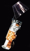
RESOURCESAT-2
#37387
(2011-015A) |
RESOURCESAT-2 was the
primary payload of a launch by India on a PSLV rocket.
Together with RESOURCESAT-2 two other satellites were
launched: YOUTHSAT and X-SAT.
The downlink frequency
of RESOURCESAT-2 is the same as RESOURCESAT-1 and thus
2250.000 MHz. |
April
20th 2011 |
1200kg |
 Enclosed
spectrum plot was kindly provided by Greg Roberts. Enclosed
spectrum plot was kindly provided by Greg Roberts.
|


|
YOUTHSAT
#37388
(2011-015B) |
YOUTHSAT was constructed
by students in India and Russia and launched by India
on PSLV-C16 (polar satellite launch vehicle).
The
main objective of the mission is to provide a platform
to aerospace students across the world for space experiments
(including studies of solar radiation) and associated
data-processing for the benefit of future generations
and humanity as a whole.
The suggested downlink
frequencies are 180.01 MHz, 400.02 MHz and 2254.340
MHz. |
April
20th 2011 |
92
kg |
 The
S-band downlink signal has been confirmed by Greg Roberts
who kindly provided the spectrum plot enclosed. The
S-band downlink signal has been confirmed by Greg Roberts
who kindly provided the spectrum plot enclosed.
|

|
X-SAT
#37389
(2011-015C) |
X-SAT is
Singapores first national satellite, operating mainly
on X-band but also carries an S-band transmitter. It
was launched by India on a PSLV rocket. It's primary
mission is Earth observation and satellite based data
acquisition/distribution/messaging using mobile terminals.
I am searching for sound files. Please
send them to
 |
April 20th
2011 |
105 kg |
|
Meridian
4
Meridian 14 L
#37398
(2011-018A) |
Meridian 4 is a Russian
military/government communications satellite launched
on a Soyuz 2-1a rocket with a Fregat upper stage from
Plesetsk, Russia. Meridian combines the military and
civilian tasks of the former Molniya-1 and Molniya-3
satellites, together with the clandestine communications
function of the outgoing LEO Parus satellites. Meridian
4has a highly elliptical orbit (HEO) with an inclination
of 63°, also called Molniya orbit. Meridian 4 has
multiple transponders:
P-Band downlink: 278.4 -
279.4 MHz,
UHF-Band downlink: 483.750 MHz,
C-Band
downlink: approx. 3600 MHz. |
May
4th 2011 |
>
2000 kg |
Paul Marsh
received on the C-Band downlink at 3610 MHz a low data
rate FSK signal of Meridian 4 on December 31st
2014 at 11:42 UTC. Audio recording kindly provided by
Paul Marsh M0EYT. |


|
RASAD-1
#37675
(2011-025A) |
Rasad 1
is the second Iranian nano-satellite. It was built by
the Malek Ashtar University in Tehran. The expected
operational life time is 2 months. It was launched on
a Safir rocket in a low earth orbit with a height of
236x299 km and an inclination of 56 degrees. It is an
experimental earth observation satellite with a resolution
of about 150 meters. Rasad-1 transmits a burst signal
on 465 MHz at about 30 kHz bandwidth. There is a second
frequency allocation for Rasad-1 at 401 MHz but it is
unclear whether this is only used for uplink or also
for downlink. |
June
15th 2011 |
15
kg |
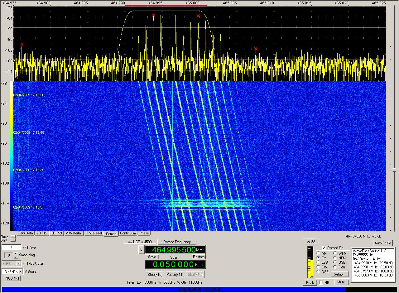
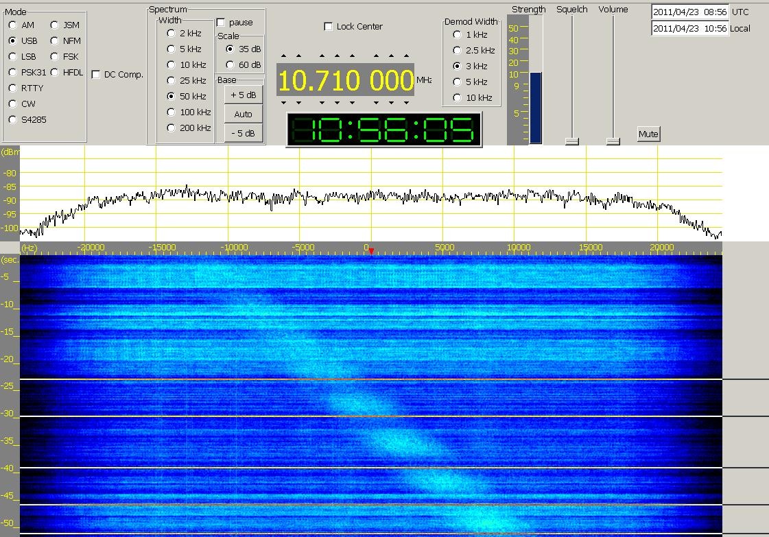
 Enclosed
signal from RASAD-1 was received on June 19th
2011 at 10:30 UTC on 465.000 MHz. The recording of the
signal and the spectrum plot were kindly provided by
Paul Marsh M0EYT from www.uhf-satcom.com. Enclosed
signal from RASAD-1 was received on June 19th
2011 at 10:30 UTC on 465.000 MHz. The recording of the
signal and the spectrum plot were kindly provided by
Paul Marsh M0EYT from www.uhf-satcom.com.
|
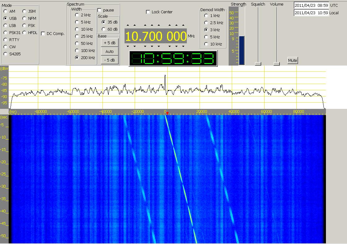
In the
following days, the downlink signal changed to a carrier
which was modulated with a 1kHz tone.  The
tone is occasionally interrupted by some short data
bursts. You can see in the spectrum and waterfall plot,
that the carrier is slightly and the 2nd
harmonic of the 1 kHz tone is significantly suppressed.
Up to the 7th harmonic of the
tone can be seen in the spectrum. The downlink signal
is sometimes switched on/off, which can be also seen
also in enclosed pass which was observed on June 26th
2011 starting at 06:30 UTC. The
tone is occasionally interrupted by some short data
bursts. You can see in the spectrum and waterfall plot,
that the carrier is slightly and the 2nd
harmonic of the 1 kHz tone is significantly suppressed.
Up to the 7th harmonic of the
tone can be seen in the spectrum. The downlink signal
is sometimes switched on/off, which can be also seen
also in enclosed pass which was observed on June 26th
2011 starting at 06:30 UTC.  The
complete pass is shown in the spectrum plot and the
two audio recordings represent the two phases of the
interrupted transmission. Besides the signal from RASAD-1
you can see a terrestrial wideband signal (in green
and blue color). A 10.7 MHz IF frequency corresponds
to a 465.000 MHz RF frequency. The
complete pass is shown in the spectrum plot and the
two audio recordings represent the two phases of the
interrupted transmission. Besides the signal from RASAD-1
you can see a terrestrial wideband signal (in green
and blue color). A 10.7 MHz IF frequency corresponds
to a 465.000 MHz RF frequency. |


|
Spektr-R
Spektr R
RadioAstron
#37755
(2011-037A) |
The Spektr-R
(formerly RadioAstron)
project is an international collaborative mission to
launch a free flying satellite carrying a 10-meter radio
telescope in high apogee orbit around the Earth. This
Russian radio astronomy satellite was launched from
Baikonur on July 18th 2011 at 02:31 UT C by a Zenit
3F rocket. The aim of the mission is to use the space
telescope to conduct interferometer observations in
conjunction with the global ground radio telescope network
in order to obtain images, coordinates, motions and
evolution of angular structure of different radio emitting
objects in the Universe with the extraordinary high
angular resolution. Spektr-R features a 8.4 GHz downlink
phase coherent downlink. |
July
18th 2011 |
3660
kg |
 Enclosed
audio file and spectrum plot of Spektr-R was received
on January 6th 2014 at 22:20
UTC on 8400.010 MHz by Paul Marsh. Enclosed
audio file and spectrum plot of Spektr-R was received
on January 6th 2014 at 22:20
UTC on 8400.010 MHz by Paul Marsh.
|
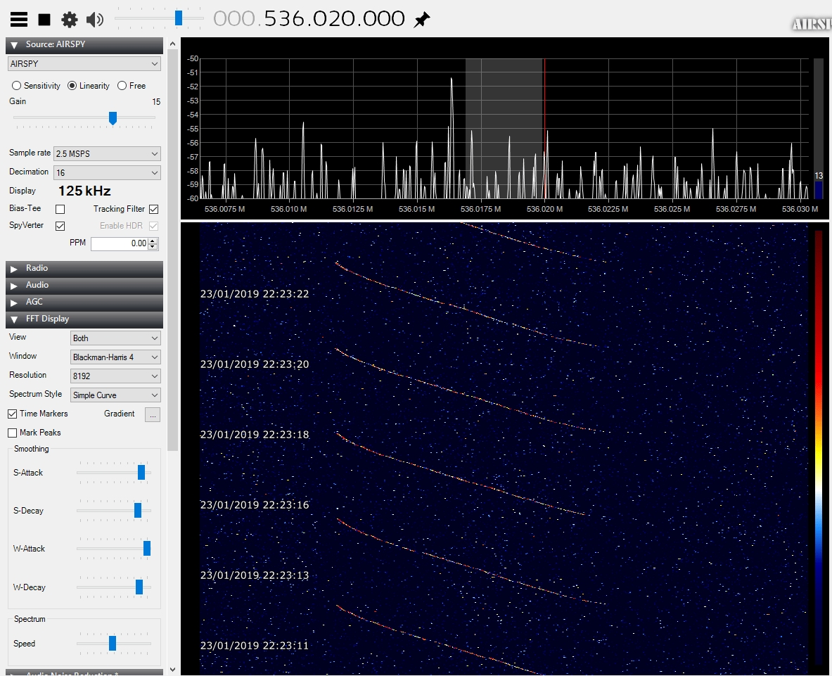
 On January
10th 2019 part of the electronic
system of Spekr-R failed due to cosmic radiation. Thus
the ground station is no more able to send commands
to the spacecraft. Nevertheless the downlink signal
could be received by Edgar DF2MZ on January 19th
2019 at 22:55 UTC on 8400 MHz. Recording and waterfall
plot kindly provided by Edgar Kaiser DF2MZ. On January
10th 2019 part of the electronic
system of Spekr-R failed due to cosmic radiation. Thus
the ground station is no more able to send commands
to the spacecraft. Nevertheless the downlink signal
could be received by Edgar DF2MZ on January 19th
2019 at 22:55 UTC on 8400 MHz. Recording and waterfall
plot kindly provided by Edgar Kaiser DF2MZ.
|
 About
two weeks later, on January 23rd
2019 at 22:23 UTC, Graham G8FXB was still able to receive
the downlink signal from Spektr-R. Recording and waterfall
plot kindly provided by Graham Leighton G8FXB. About
two weeks later, on January 23rd
2019 at 22:23 UTC, Graham G8FXB was still able to receive
the downlink signal from Spektr-R. Recording and waterfall
plot kindly provided by Graham Leighton G8FXB.
|
 Also
on on January 24th 2019 at
21:59 UTC, Graham G8FXB received the signal from Spectr-R
even though it was weaker than the day before. He kindly
provided me the enclosed video of the reception. Also
on on January 24th 2019 at
21:59 UTC, Graham G8FXB received the signal from Spectr-R
even though it was weaker than the day before. He kindly
provided me the enclosed video of the reception.
|


|
TACSAT-4
INP
#37818
(2011-052A) |
TACSAT 4 also known
as INP (Tactical Microsatellite Innovative Naval Prototype)
is a US Navy 4th generation communications satellite
featuring 10 UHF communications channels and a 3.8m
wide deployable dish antenna. Power is generated by
2 deployable solar cell arrays. TACSAT-4 was launched
into a highly elliptical orbit from Kodiak by a Minotaur-4
rocket. The geo-synchronous orbit features an apogee
of 12050 km. |
Sept.
27th 2011 |
450
kg |
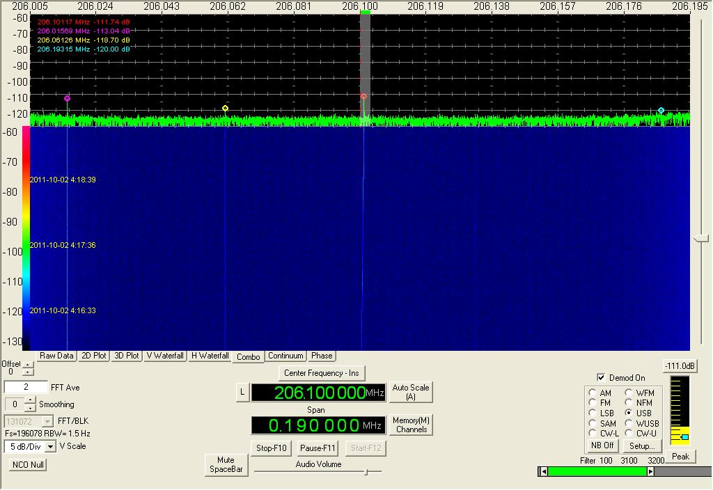
 The
S-band downlink of TACSAT-4 was received on 2206.1044
MHz on October 2st 2011 from
04:03 until 06:06 UTC by Loren Moline WA7SKT. Enclosed
spectrum plot was generated at 04:17 UTC and kindly
provided by Loren. The
S-band downlink of TACSAT-4 was received on 2206.1044
MHz on October 2st 2011 from
04:03 until 06:06 UTC by Loren Moline WA7SKT. Enclosed
spectrum plot was generated at 04:17 UTC and kindly
provided by Loren.
|
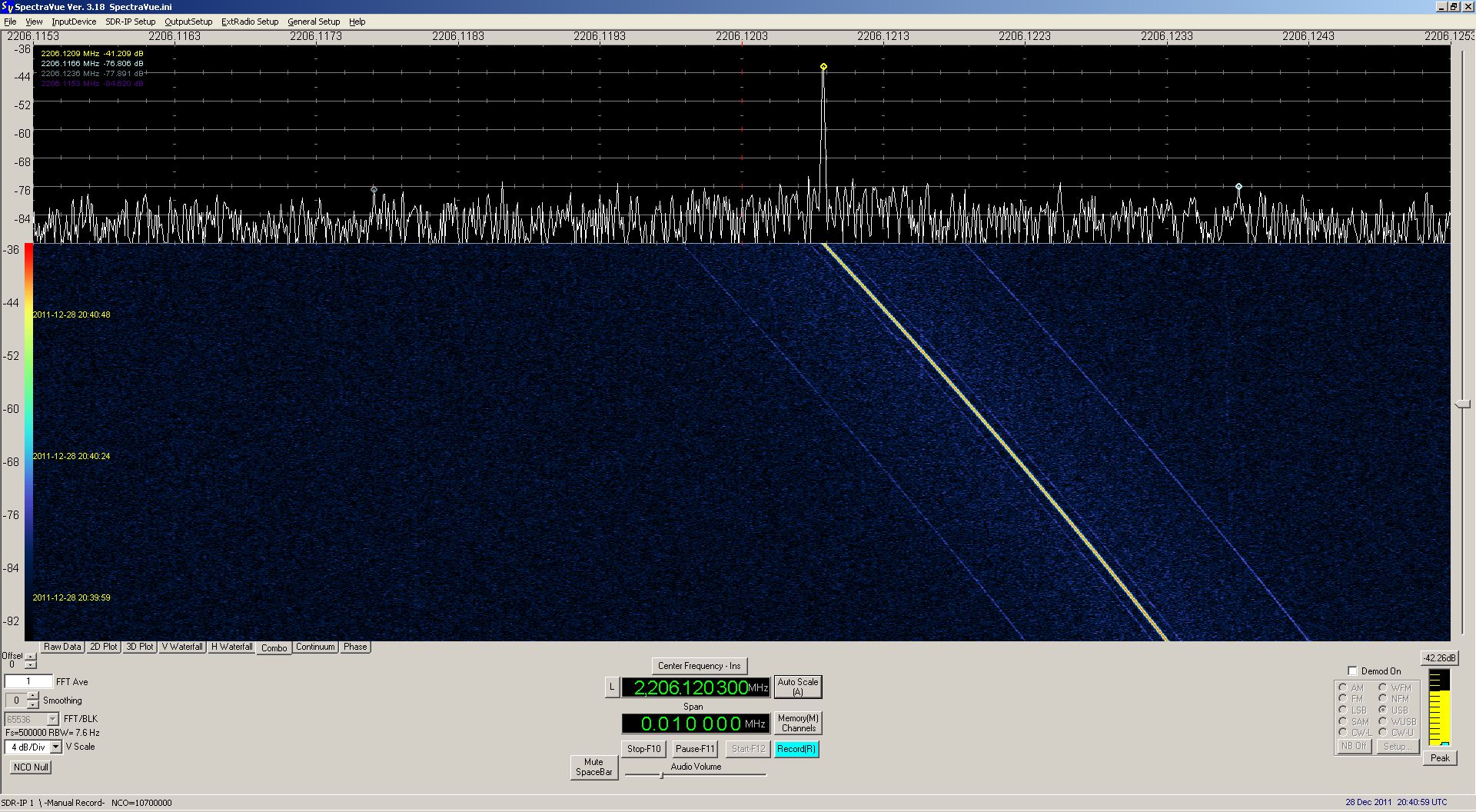
 Enclosed
audio recording and associated spectrum plot of TACSAT-4
was received on December 28th
2011 at 20:40 UTC on 2206.120 MHz by Paul Marsh. Enclosed
audio recording and associated spectrum plot of TACSAT-4
was received on December 28th
2011 at 20:40 UTC on 2206.120 MHz by Paul Marsh.
|


|
JUGNU
JNU
#37839
(2011-058B) |
This nanosatellite based
on a triple cubesat design was built by a team of 12
professors and 40 students from IIT-K (Indian Institute
of Technology Kanpur) in India. It was launched by PSLV
C-18 from Satish Space Centre (SDSC), Shriharikota,
India into a LEO orbit with 20 degrees inclination.
The primary payload was Mega-Tropique, a French/Indian
meteorological satellite.
JNU carries a micro-imaging
system, a GPS receiver and a MEMS based intertial measurement
unit. The downlink frequency of the CW telemetry beacon
with an output power of 50 mW is 437.275 MHz. |
Oct.
12th 2011 |
3.5
kg |
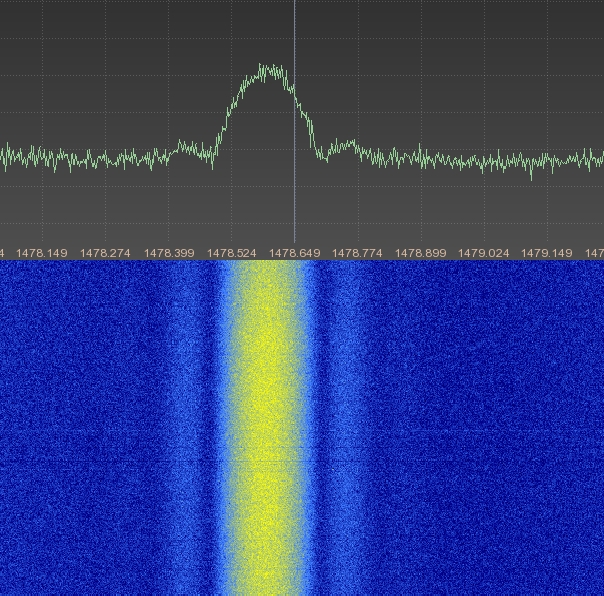
Enclosed
CW telemetry signal of JUGNU was received and recorded
by Noguchi-san JA5BLZ on October 14th
2011 at 03:29 UTC. Kindly provided by Tetsu-san JA0CAW. |


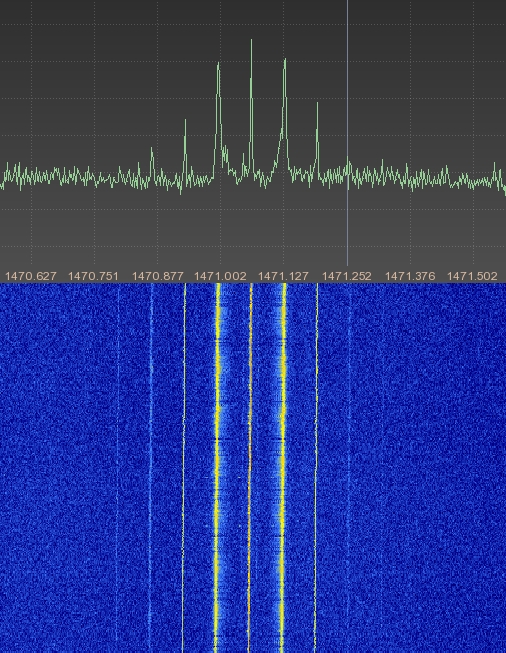
|
SRMSAT
SRMVU
#37841
(2011-058D) |
SRMSat is
a 10.4 kg Cubesat built by SRM University in Chennai,
India. It was launched by PSLV C-18 from Satish Space
Centre (SDSC), Shriharikota, India into a LEO orbit.
Because of its low inclination of only 20 degrees in
conjunction with its low altitude SRMSat will never
be received in Central Europe or at higher latitudes.
 The
CW-Beacon frequency is 437.425 MHz, its output power
is 10 mW. Enclosed file explains the telemetry format. The
CW-Beacon frequency is 437.425 MHz, its output power
is 10 mW. Enclosed file explains the telemetry format. |
Oct.
12th 2011 |
10
kg |
Enclosed
recording of SRMSat was received by JA0CAW on October
12th 2011 at 20:28 UTC. Recording
kindly provided by Tetsu-san JA0CAW. |
Enclosed
recording of SRMSat was received by JA0CAW on October
12th 2011 at 22:16 UTC. Recording
kindly provided by Tetsu-san JA0CAW. |


|
NPP
Suomi NPP
#37849
(2011-061A) |
NPP (NPOESS
Preparatory Project) was launched on October 28th
2011 on a Boeing Delta-2 rocket from Vandenberg Air
Force Base in California. The satellite was placed into
a sun-synchronous
orbit 824 km above the Earth. As part
of the National Polar-Orbiting Operational Environmental
Satellite System (NPOESS) it studies global change,
including atmospheric temperature and humidity sounding,
sea-surface temperature, land and ocean biological productivity,
cloud and aerosol properties and global ozone levels.
After initial check out in orbit, NASA renamed the spacecraft
on January 24th 2012 to Suomi
National Polar-orbiting Partnership,
or Suomi NPP in honor
of the late Verner E. Suomi, a meteorologist at the
University of Wisconsin who is recognized widely as
"the father of satellite meteorology."
NPP transmits in X-Band and in S-Band. The downlink
frequencies are:
- 8212.5 MHz with 300 MBit/s (to
Gnd statiom in Norway)
- 7812 MHz with 30 Mbit/s
(DBS real time high data rate)
- 2247.5 MHz with
up to 512 kbit/s (TLM)
- 2067.270833 MHz with 2
& 128 kbit/s (CMD).
I am searching for sound files. Please
send them to
|
Oct 28th
2011 |
1976 kg |

|
RAX-2
#37853
(2011-061D) |
RAX (Radio
Aurora Explorer) is a joint venture between the University
of Michigan and SRI International. Its primary mission
objective is to study large plasma formations in the
ionosphere, the highest region of our atmosphere. This
second RAX satellite was launched on October 28th
2011 as part of the ELaNa3 (Educational Launch of Nanosatellites)
Mission on a Boeing Delta-2 rocket from Vandenberg Air
Force Base in California. The primary payload was NPOESS.
The radio payload includes a bistatic radar receiver
(426-512 MHz), a GPS receiver, a 2.4 GHz 115kbps GMSK
transceiver and a UHF 38.4kbps transceiver which is
also used for the Amateur Radio telemetry downlink.
This downlink at 437.345 MHz uses GMSK modulation to
broadcast a 9600bd data downlink signal ever 20 seconds.
The callsign used is RAX-1 as the team did forget to
change it during the launch preparation. The downlink
transmit power is 750 mW and the polarization used is
RHCP. |
Oct
28th 2011 |
2.8
kg |
Henk PA3GUO was one of
the first to receive RAX-2 telemetry on Oct 28th
2011. |
On November
7th 2011 at 18:34 UTC Mike
Rupprecht received the 9k6 FSK downlink of RAX-2 . Enclosed
recording kindly provided by Mike DK3WN. |

|
M-Cubed
M3
#37855
(2011-061F) |
M-Cubed is a satellite
built by the University of Michigan's Students Space
Systems Fabrication Lab (S3FL)
and part of the ELaNa3 (Educational Launch of Nanosatellites)
Mission. It is a Multipurpose Minisat based on 1U CubeSat
structure. The objective of MCubed is to obtain a mid
resolution image to date of Earth with at least 60%
land mass and a maximum of 20% cloud coverage from a
single cubesat platform.
M-Cubed is transmitting
on 437.485 MHz 9600bd FSK AX.25 packets. Its EIRP <
1 Watt. The uplink frequency is at 145.950 MHz. |
Oct
28th 2011 |
1
kg |
Receiving
and decoding M-Cubed turns out to be quite difficult.
Mike DK3WN was able to receive and record enclosed 9600bd
signal from M-Cubed on December 27th
2011 at 05:20 UTC. Kindly provided by Mike DK3WN. |


|
Explorer-1
Prime-2
E1P-U2
HRBE
#37855
(2011-061F) |
Explorer 1 Prime (E1P)
is a 1U Cubesat-class satellite developed by the Space
Science and Engineering Laboratory (SSEL) at Montana
State University. Its mission is to detect the Van Allen
radiation belts in honor of the 50th anniversary of
Explorer-1, America's first satellite that first discovered
the cloud of highly energetic electrons trapped in the
Earth's magnetic field. E1P-U2 (Explorer 1 Prime 2)
is a re-flight of the satellite that failed to be orbited
on March 4th 2011. It was launched
on a Boeing Delta-2 rocket from Vandenberg Air Force
Base in California. After successful launch it was renamed
for William H. Hiscock to HRBE (Hiscock Radiation Belt
Explorer). It is transmitting its beacon every 15 seconds
in non-coherent 1200bd FSK modulation on 437.505 MHz.
The transmit power is 0.85 Watts EIRP. The protocol
in use is KISS, the callsign used is K7MSU-02. |
Oct
28th 2011 |
1
kg |
Jan PE0SAT
was one of the first to receive E1P-U2's downlink signal.
He reported that the signal was very strong. Enclosed
recording in FM mode was made on on Oct 28th
2011 at 12:40 UTC and kindly provided by Jan PE0SAT. |
Enclosed
recording in LSB mode, which is the proper way to receive
this modulation scheme, was made during the next pass
on Oct 28th 2011 at 14:17 UTC
and kindly provided by Jan PE0SAT. |
On December
27th 2011 at 13:00 UTC Mike
Rupprecht received the 1200bd AFSK downlink of E1P-U2
in LSB. Enclosed recording kindly provided by Mike DK3WN. |

|
Tianxun-1
Tian Xun 1
TX-1
#37874
(2011-066A) |
TX 1(Tian Xun 1)
was launched from Taiyuan by a Long March 4B rocket.
The microsatellite weighs 35 kg and was designed by
Nanjing University of Aeronautics and Astronautics for
a mission of technological verification tests. It is
equipped with a 2.5 kg CCD camera, developed by the
students of the Suzhou University, which can provide
a maximum resolution of 30 m. |
Noc
9th 2011 |
35
kg |
 The
S-Band TT&C downlink on 2276.45 MHz of Tianxun-1
was received and enclosed FFT plot was generated in
June 2014 by Milen Rangelov. The
S-Band TT&C downlink on 2276.45 MHz of Tianxun-1
was received and enclosed FFT plot was generated in
June 2014 by Milen Rangelov.
|


|
Pleiades
1
#38012
(2011-076F) |
Pleiades 1 is a
French Earth observation satellite launched from Kourou
by a Soyuz rocket into a LEO orbit. Pleiades 1 is a
multi-role observation craft. It collects each day 450
high-resolution (features as small as 0.5 m) optical
images for military and civilian users, including tri-stereo
imagery and mosaics. It was designed by
the French Space Agency (CNES) for a five-year mission. |
Dec
17th 2011 |
970
kg |
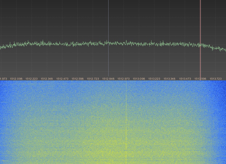
 The
S-Band downlink on 2269.2 MHz of Pleiades 1 was received
and enclosed FFT plot was generated in May 2014 by Milen
Rangelov. The
S-Band downlink on 2269.2 MHz of Pleiades 1 was received
and enclosed FFT plot was generated in May 2014 by Milen
Rangelov.
|
Picture |
Object
name
#NORAD |
Description |
Launch
Date |
Weight |